IMAGES TAKEN NEAR TO
Cemetery Road, GALSTON, KA4 8JU
Introduction
This page details the photographs taken nearby to Cemetery Road, KA4 8JU by members of the Geograph project.
The Geograph project started in 2005 with the aim of publishing, organising and preserving representative images for every square kilometre of Great Britain, Ireland and the Isle of Man.

There are currently over 7.5m images from over14,400 individuals and you can help contribute to the project by visiting https://www.geograph.org.uk
Image Map
Images are licensed for reuse under creativecommons.org/licenses/by-sa/2.0
Notes
- Clicking on the map will re-center to the selected point.
- The higher the marker number, the further away the image location is from the centre of the postcode.
Image Listing (111 Images Found)
Images are licensed for reuse under creativecommons.org/licenses/by-sa/2.0
Image
Details
Distance

3
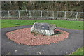
Galston Coal Mining Memorial
At the beginning of the 19th century Galston’s character and appearance began to change from a textile and agricultural centre to a major coal mining area. The arrival of the railway from Kilmarnock in 1848 allowed new coal seams to open up. Towards the end of the 19th century Galston had fifteen pits around the town employing around one thousand miners. (a warren of disused mines lies far below the streets) This brought wealth to the town allowing significant expansion and bound generations of the town’s people together. The 20th Century saw the decline of mining locally and the last pit (Maxwood Pit) sadly closed in 1933. The Goatfoot Colliery was situated where the Barrwood Gate housing development on the main road to Kilmarnock is now sited. Deep coal mining was dangerous and treacherous, many lost their lives. In 2009 the Galston Memorial Cairn was dedicated to the memory of the men and boys who died in the local mining industry.
Source : Galston Heritage Trail.
Image: © Raibeart MacAoidh
Taken: 17 Apr 2019
0.09 miles
4
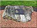
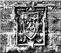
Mining memorial stone
The plaque reads: "In memory of the boys and men of Galston and Loudoun Parishes who were killed in the mining industry and whose names are recorded elsewhere". There’s nothing left to show that collieries ever existed in this area although they were the major local employers for many years. The plaque also reminds us of days when young boys were expected to work in the pits alongside their fathers.
Image: © Mary and Angus Hogg
Taken: 8 Aug 2020
0.09 miles
5
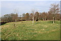
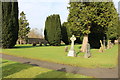
Meadow and Woodland Burial Site, Galston
Image: © Billy McCrorie
Taken: 25 Feb 2019
0.09 miles
6
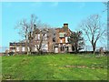
Galston Primary School (Former), Glebe Road, Galston
Image: © Raibeart MacAoidh
Taken: 17 Apr 2019
0.10 miles
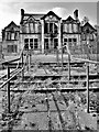
7
Galston Primary School (Former), Glebe Road, Galston
Image: © Raibeart MacAoidh
Taken: 17 Apr 2019
0.10 miles
8
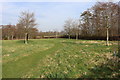
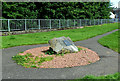
Meadow and Woodland Burial Site, Galston
Image: © Billy McCrorie
Taken: 25 Feb 2019
0.10 miles
9
Galston Primary School (Former), Glebe Road, Galston
Image: © Raibeart MacAoidh
Taken: 17 Apr 2019
0.10 miles