IMAGES TAKEN NEAR TO
Wallace Street, GALSTON, KA4 8HP
Introduction
This page details the photographs taken nearby to Wallace Street, KA4 8HP by members of the Geograph project.
The Geograph project started in 2005 with the aim of publishing, organising and preserving representative images for every square kilometre of Great Britain, Ireland and the Isle of Man.

There are currently over 7.5m images from over14,400 individuals and you can help contribute to the project by visiting https://www.geograph.org.uk
Image Map
Images are licensed for reuse under creativecommons.org/licenses/by-sa/2.0
Notes
- Clicking on the map will re-center to the selected point.
- The higher the marker number, the further away the image location is from the centre of the postcode.
Image Listing (107 Images Found)
Images are licensed for reuse under creativecommons.org/licenses/by-sa/2.0
Image
Details
Distance
2
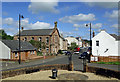
Barr Castle view
Looking towards Wallace Street from Barr Castle. The large Romanesque-style building left of centre is the Erskine Hall, which started life as a church in 1859.
Image: © Mary and Angus Hogg
Taken: 8 Aug 2020
0.01 miles
3
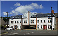
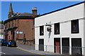
Flats in Wallace Street, Galston
These flats in Wallace Street are built on the site of an old cinema.
Image: © Mary and Angus Hogg
Taken: 8 Aug 2020
0.02 miles
4

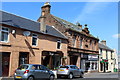
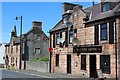
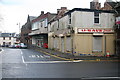
'The Four Corners' - Galston
The junction of Polworth Street, Bridge Street, Henrietta Street and Wallace Street is locally known as 'The Four Corners'.
The building on the left (Polwarth Street) was The Blair School. In 1841 Charles Blair set up a free school for children from poorer families. He owned a local lint mill. The School had an Education Trust which provided each pupil with school clothing and £5 for the top boy and top girl leaving school each year.
George Paterson was the first school master and held the post for over 30 years. He is buried in Loudoun Kirkyard.
The Education Act of 1872 meant free schooling for all. This resulted in all children going to these schools: Barr School - Primary 1-2. Burnside School – up to age 12 (1910 age increased) and Higher Grade School (Glebe Road) – up to age 14 until 1972 when Loudoun Academy opened. It then became a Junior Secondary finally becoming Galston Primary School. Galston Primary moved to a new site on Western Road in 2010.
Roman Catholic Education began with St Sophia’s Primary in 1884 next to St Sophia’s Church, later moving to Nelville Drive.
Image: © Raibeart MacAoidh
Taken: 19 May 2019
0.03 miles
6
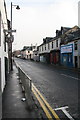
Brewland Street, Galston
An interesting sign for "The Sporran".
Image: © Dan
Taken: 2 Feb 2009
0.04 miles
8
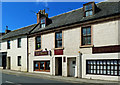
Masons Arms, Henrietta Street, Galston
Dated 1825
Image: © Leslie Barrie
Taken: 31 May 2014
0.05 miles
9
Dan-Druffs
An interesting name for this gents’ barber shop in Galston.
Image: © Mary and Angus Hogg
Taken: 8 Aug 2020
0.06 miles
10
It did not save U Save
Titchfield Street, Galston.
Image: © Dan
Taken: 2 Feb 2009
0.06 miles