IMAGES TAKEN NEAR TO
Wallace Street, GALSTON, KA4 8GZ
Introduction
This page details the photographs taken nearby to Wallace Street, KA4 8GZ by members of the Geograph project.
The Geograph project started in 2005 with the aim of publishing, organising and preserving representative images for every square kilometre of Great Britain, Ireland and the Isle of Man.

There are currently over 7.5m images from over14,400 individuals and you can help contribute to the project by visiting https://www.geograph.org.uk
Image Map
Images are licensed for reuse under creativecommons.org/licenses/by-sa/2.0
Notes
- Clicking on the map will re-center to the selected point.
- The higher the marker number, the further away the image location is from the centre of the postcode.
Image Listing (106 Images Found)
Images are licensed for reuse under creativecommons.org/licenses/by-sa/2.0
Image
Details
Distance
1
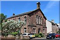
Former United Presbyterian Church, Wallace Street, Galston
Rebuilt 1859. Now converted for residential use.
Image: © Leslie Barrie
Taken: 31 May 2014
0.00 miles
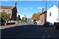
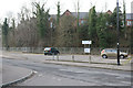
5
Barr Castle Gardens, Galston
At the junction with Barr Street.
Image: © Billy McCrorie
Taken: 14 Oct 2014
0.03 miles
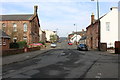
9
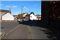
Barr Street, Galston
Building on the right is Barr Castle.
Image: © Billy McCrorie
Taken: 14 Oct 2014
0.03 miles