IMAGES TAKEN NEAR TO
Brewland Street, GALSTON, KA4 8DY
Introduction
This page details the photographs taken nearby to Brewland Street, KA4 8DY by members of the Geograph project.
The Geograph project started in 2005 with the aim of publishing, organising and preserving representative images for every square kilometre of Great Britain, Ireland and the Isle of Man.

There are currently over 7.5m images from over14,400 individuals and you can help contribute to the project by visiting https://www.geograph.org.uk
Image Map
Images are licensed for reuse under creativecommons.org/licenses/by-sa/2.0
Notes
- Clicking on the map will re-center to the selected point.
- The higher the marker number, the further away the image location is from the centre of the postcode.
Image Listing (14 Images Found)
Images are licensed for reuse under creativecommons.org/licenses/by-sa/2.0
Image
Details
Distance

3
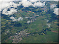
The Upper Irvine Valley
Working away from the camera, can be seen the towns of Galston, Newmilns and Darvel.
Image: © Thomas Nugent
Taken: 7 Aug 2017
0.12 miles


8
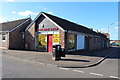
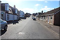
The Wee Shop, Galston
On the corner of Milton Road and Orchard Street.
Image: © Billy McCrorie
Taken: 14 Oct 2014
0.23 miles
9
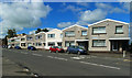
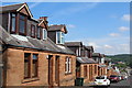
Houses in Brewland Street
A row of houses set into the slope at the bottom end of Galston's Brewland Street.
Image: © Mary and Angus Hogg
Taken: 8 Aug 2020
0.23 miles
10
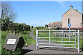
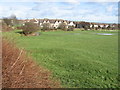
The Chris Hoy Cycle Way
Follows the dismantled railway from Galston to Hurlford
Image: © Leslie Barrie
Taken: 31 May 2014
0.23 miles