IMAGES TAKEN NEAR TO
Arran Point, GALSTON, KA4 8AG
Introduction
This page details the photographs taken nearby to Arran Point, KA4 8AG by members of the Geograph project.
The Geograph project started in 2005 with the aim of publishing, organising and preserving representative images for every square kilometre of Great Britain, Ireland and the Isle of Man.

There are currently over 7.5m images from over14,400 individuals and you can help contribute to the project by visiting https://www.geograph.org.uk
Image Map
Images are licensed for reuse under creativecommons.org/licenses/by-sa/2.0
Notes
- Clicking on the map will re-center to the selected point.
- The higher the marker number, the further away the image location is from the centre of the postcode.
Image Listing (6 Images Found)
Images are licensed for reuse under creativecommons.org/licenses/by-sa/2.0
Image
Details
Distance
1

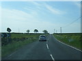
Crossroads on the A719
A minor road from Kilmarnock forms a crossroads when it meets the A719 road. Just next the crossroads is Arranview Holiday Park whose entrance is seen here.
Image: © Alec MacKinnon
Taken: 25 Apr 2022
0.11 miles
2
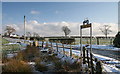
A719, Grassyards Bridge
Between Moscow and Waterside this small bridge takes the road across Grassyards Burn. On the hill is Darwhilling Farm.
Image: © wfmillar
Taken: 16 Sep 2009
0.13 miles