IMAGES TAKEN NEAR TO
Cross Street, GALSTON, KA4 8AA
Introduction
This page details the photographs taken nearby to Cross Street, KA4 8AA by members of the Geograph project.
The Geograph project started in 2005 with the aim of publishing, organising and preserving representative images for every square kilometre of Great Britain, Ireland and the Isle of Man.

There are currently over 7.5m images from over14,400 individuals and you can help contribute to the project by visiting https://www.geograph.org.uk
Image Map
Images are licensed for reuse under creativecommons.org/licenses/by-sa/2.0
Notes
- Clicking on the map will re-center to the selected point.
- The higher the marker number, the further away the image location is from the centre of the postcode.
Image Listing (108 Images Found)
Images are licensed for reuse under creativecommons.org/licenses/by-sa/2.0
Image
Details
Distance
2
Galston Parish Church
The first church on the site was dedicated to St Peter and was built before the end of the 13th century as one of the five parish churches belonging to the Monastery of Fail.
The present church was built 1808-09 during the ministry of the Rev. George Smith (1778-1823) the great grandfather of Robert Louis Stevenston. He was also immortalised by figuring in three poems of Robert Burns "The Holy Fair," "The Twa Herds" and "The Kirk's Alarm."
Image: © Raibeart MacAoidh
Taken: 24 May 2019
0.02 miles
3
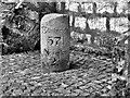
Milestone at Galston Cross
For centuries Galston was confined to the old ‘Kirk Toun’ by the parish church (The Cross, Church Lane then a drover’s road and the area around Bridge Street and Brewland Street). Galston Cross was the site of the Mercat Cross and horse trough. This focal point of the town hosted agricultural fairs and celebratory events and was a place for people to meet. This was not the original position of the milestone - that was just outside the town, on the north side of the River Irvine, about 100 yards from the Muckle Brig on LH side of road heading to Newmilns. It may have been moved from there when the bypass was built in the late 70's
Original position on milestone https://www.geograph.org.uk/photo/6048613
Image: © Raibeart MacAoidh
Taken: 19 May 2019
0.03 miles
4

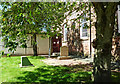
Galston Parish Church, Ayrshire
Galston Parish Church. To the front right is a memorial garden, 'Dunblane Garden', built to commemorate the lives of the 16 children and their teacher killed in Dunblane in 1996.
Image: © L J Cunningham
Taken: 1 Oct 2005
0.04 miles
5

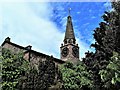
Galston Parish Church
The Georgian-style church of 1809 stands on a site of a building dating back to 1252. At 120 feet high, the steeple is a prominent local landmark. The graveyard contains some Covenanting gravestones.
Image: © Mary and Angus Hogg
Taken: 8 Aug 2020
0.04 miles
6
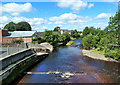
The River Irvine at Galston
Looking downstream from Galston Bridge showing Burn Anne entering from the left.
Image: © Mary and Angus Hogg
Taken: 8 Aug 2020
0.04 miles
7

Here lies Andrew Richmond
Detail of the grave of Covenanter Andrew Richmond, showing him praising the Lord while Claverhouse aims a gun at him. This was how many Covenanters died in “The Killing Times” of the late 17th century. The full stone is shown at Image
Image: © Mary and Angus Hogg
Taken: 8 Aug 2020
0.05 miles
8
Covenanters' resting place
The site of the well-known Covenanter graves at Galston Parish Church.
Image: © Mary and Angus Hogg
Taken: 8 Aug 2020
0.05 miles
9

Galston Parish Church view
Viewed from the next square at the bottom end of Brewland Street.
Image: © Mary and Angus Hogg
Taken: 8 Aug 2020
0.05 miles
10
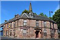
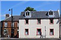
Portland Arms Hotel, Galston
On the corner of Brewland Street and Cross Street
Image: © Leslie Barrie
Taken: 31 May 2014
0.05 miles