IMAGES TAKEN NEAR TO
Baird Place, KILMARNOCK, KA3 7RL
Introduction
This page details the photographs taken nearby to Baird Place, KA3 7RL by members of the Geograph project.
The Geograph project started in 2005 with the aim of publishing, organising and preserving representative images for every square kilometre of Great Britain, Ireland and the Isle of Man.

There are currently over 7.5m images from over14,400 individuals and you can help contribute to the project by visiting https://www.geograph.org.uk
Image Map
Images are licensed for reuse under creativecommons.org/licenses/by-sa/2.0
Notes
- Clicking on the map will re-center to the selected point.
- The higher the marker number, the further away the image location is from the centre of the postcode.
Image Listing (39 Images Found)
Images are licensed for reuse under creativecommons.org/licenses/by-sa/2.0
Image
Details
Distance
1
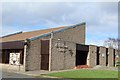
St Matthew's Church, Kilmarnock
Built 1977
Image: © Leslie Barrie
Taken: 23 Mar 2014
0.14 miles
2
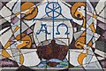
Mosaic, St Matthew's Church, Kilmarnock
Image: © Leslie Barrie
Taken: 23 Mar 2014
0.14 miles
3
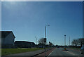
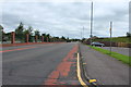
Grassyards Road
Having gone too far north we are heading south on Grassyards Road to find Dean Castle Country Park.
Image: © Malcolm Neal
Taken: 20 Mar 2022
0.14 miles
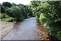
8
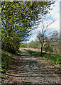
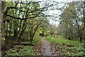
By Kilmarnock Water in the hail
I started out on this path in lovely sunshine which was interrupted by a fall of hail. A few minutes later, the darkening sky and thickening hail made me head for shelter.
Image: © Mary and Angus Hogg
Taken: 5 May 2021
0.17 miles