IMAGES TAKEN NEAR TO
Wellington Gardens, KILMARNOCK, KA3 6NE
Introduction
This page details the photographs taken nearby to Wellington Gardens, KA3 6NE by members of the Geograph project.
The Geograph project started in 2005 with the aim of publishing, organising and preserving representative images for every square kilometre of Great Britain, Ireland and the Isle of Man.

There are currently over 7.5m images from over14,400 individuals and you can help contribute to the project by visiting https://www.geograph.org.uk
Image Map
Images are licensed for reuse under creativecommons.org/licenses/by-sa/2.0
Notes
- Clicking on the map will re-center to the selected point.
- The higher the marker number, the further away the image location is from the centre of the postcode.
Image Listing (5 Images Found)
Images are licensed for reuse under creativecommons.org/licenses/by-sa/2.0
Image
Details
Distance
2
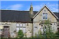
Former Crookedholm School
Category C-listed. Dated 1875.
Image: © Leslie Barrie
Taken: 31 May 2014
0.20 miles
3
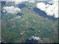
Farmland at Crookedholm from the air
Crookedholm is a village on the west side of Kilmarnock, it can be seen in the foreground. The River Irvine meanders through the scene.
Image: © Thomas Nugent
Taken: 17 Apr 2017
0.21 miles