IMAGES TAKEN NEAR TO
Wellington Avenue, KILMARNOCK, KA3 6LN
Introduction
This page details the photographs taken nearby to Wellington Avenue, KA3 6LN by members of the Geograph project.
The Geograph project started in 2005 with the aim of publishing, organising and preserving representative images for every square kilometre of Great Britain, Ireland and the Isle of Man.

There are currently over 7.5m images from over14,400 individuals and you can help contribute to the project by visiting https://www.geograph.org.uk
Image Map
Images are licensed for reuse under creativecommons.org/licenses/by-sa/2.0
Notes
- Clicking on the map will re-center to the selected point.
- The higher the marker number, the further away the image location is from the centre of the postcode.
Image Listing (8 Images Found)
Images are licensed for reuse under creativecommons.org/licenses/by-sa/2.0
Image
Details
Distance
1
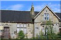
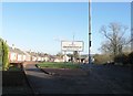
Former Crookedholm School
Category C-listed. Dated 1875.
Image: © Leslie Barrie
Taken: 31 May 2014
0.14 miles
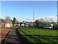
2
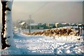
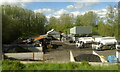
Milton Road, Kilmarnock
Shortly after a snow storm in 1980's. Looking towards Kilmarnock the footbridge across A77 is visible in the left middle of picture.
Image: © Tom Morrison
Taken: Unknown
0.16 miles
4
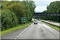
Railway Bridge over the Kilmarnock Bypass
Image: © David Dixon
Taken: 22 Sep 2019
0.23 miles
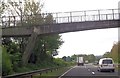
7
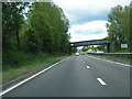
A77 northbound passes under railway bridge
Image: © Colin Pyle
Taken: 4 Jun 2013
0.24 miles