IMAGES TAKEN NEAR TO
Main Road, KILMARNOCK, KA3 6JZ
Introduction
This page details the photographs taken nearby to Main Road, KA3 6JZ by members of the Geograph project.
The Geograph project started in 2005 with the aim of publishing, organising and preserving representative images for every square kilometre of Great Britain, Ireland and the Isle of Man.

There are currently over 7.5m images from over14,400 individuals and you can help contribute to the project by visiting https://www.geograph.org.uk
Image Map
Images are licensed for reuse under creativecommons.org/licenses/by-sa/2.0
Notes
- Clicking on the map will re-center to the selected point.
- The higher the marker number, the further away the image location is from the centre of the postcode.
Image Listing (9 Images Found)
Images are licensed for reuse under creativecommons.org/licenses/by-sa/2.0
Image
Details
Distance
6
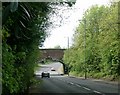
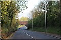
Railway Viaduct
Hedge in the way, but this shows a coal train crossing the viaduct
Image: © Scott
Taken: 29 Oct 2014
0.14 miles

8
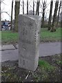
Old Milestone by the B7073, London Road, Kilmarnock
Ayr granite by the B7073, in parish of Kilmarnock (East Ayrshire District), Kilmarnock, between road bridge over A77 and railway bridge.
Surveyed
Milestone Society National ID: AYE_KMCM01
Image: © Milestone Society
Taken: Unknown
0.22 miles