IMAGES TAKEN NEAR TO
Main Road, KILMARNOCK, KA3 6JU
Introduction
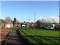
This page details the photographs taken nearby to Main Road, KA3 6JU by members of the Geograph project.
The Geograph project started in 2005 with the aim of publishing, organising and preserving representative images for every square kilometre of Great Britain, Ireland and the Isle of Man.

There are currently over 7.5m images from over14,400 individuals and you can help contribute to the project by visiting https://www.geograph.org.uk
Image Map
Images are licensed for reuse under creativecommons.org/licenses/by-sa/2.0
Notes
- Clicking on the map will re-center to the selected point.
- The higher the marker number, the further away the image location is from the centre of the postcode.
Image Listing (14 Images Found)
Images are licensed for reuse under creativecommons.org/licenses/by-sa/2.0
Image
Details
Distance
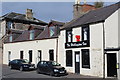
3
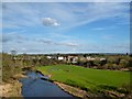
Main Road, Hurlford
Looking towards Kilmarnock.
Image: © Gordon Brown
Taken: 17 Dec 2014
0.13 miles
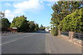
5
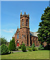
The former Hurlford Kirk
Built in 1875, this was the original parish church for Hurlford. After a merger with the Free Church in 1996, the building was converted for housing.
Image: © Mary and Angus Hogg
Taken: 13 Aug 2020
0.16 miles
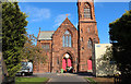
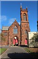
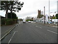
9

Former Hurlford Kirk
Category B-listed. Built 1875. Architect J Ingram of Kilmarnock.
Image: © Leslie Barrie
Taken: 5 Oct 2013
0.16 miles
