IMAGES TAKEN NEAR TO
Crookedholm, KILMARNOCK, KA3 6HW
Introduction
This page details the photographs taken nearby to KA3 6HW by members of the Geograph project.
The Geograph project started in 2005 with the aim of publishing, organising and preserving representative images for every square kilometre of Great Britain, Ireland and the Isle of Man.

There are currently over 7.5m images from over14,400 individuals and you can help contribute to the project by visiting https://www.geograph.org.uk
Image Map
Images are licensed for reuse under creativecommons.org/licenses/by-sa/2.0
Notes
- Clicking on the map will re-center to the selected point.
- The higher the marker number, the further away the image location is from the centre of the postcode.
Image Listing (5 Images Found)
Images are licensed for reuse under creativecommons.org/licenses/by-sa/2.0
Image
Details
Distance
1
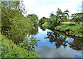
River Irvine view
An upstream view of the River Irvine near the popular riverside footpath between Templetonburn and Hurlford.
Image: © Mary and Angus Hogg
Taken: 19 Aug 2020
0.18 miles
2
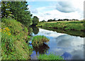
By the River Irvine
A mid-August view taken from the popular local footpath between Milton Road and Hurlford Bridge.
Image: © Mary and Angus Hogg
Taken: 19 Aug 2020
0.19 miles
3
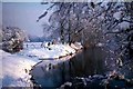
Winter Scene at "The Bishop's"
This is a secluded yet popular spot on the banks of the River Irvine. Known locally as "The Bishop's".
Image: © Tom Morrison
Taken: Unknown
0.21 miles
5
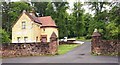
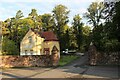
Lodgehouse and entrance to Templetonburn
Originally known as Silverwood, the lands around here at one time belonged to the Knights Templar.
Image: © Gordon Brown
Taken: 30 Jun 2020
0.25 miles