IMAGES TAKEN NEAR TO
KILMARNOCK, KA3 6HS
Introduction
This page details the photographs taken nearby to KA3 6HS by members of the Geograph project.
The Geograph project started in 2005 with the aim of publishing, organising and preserving representative images for every square kilometre of Great Britain, Ireland and the Isle of Man.

There are currently over 7.5m images from over14,400 individuals and you can help contribute to the project by visiting https://www.geograph.org.uk
Image Map (Loading...)


Getting Data...Please wait
Leaflet Map data © OpenStreetMap
Images are licensed for reuse under creativecommons.org/licenses/by-sa/2.0
Notes
- Clicking on the map will re-center to the selected point.
- The higher the marker number, the further away the image location is from the centre of the postcode.
Image Listing (6 Images Found)
Images are licensed for reuse under creativecommons.org/licenses/by-sa/2.0
Image
Details
Distance
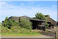
1
Houses at Grougar Row
A 1918 report described this miners' row as follows: "This row contains eighteen houses, and is situated on the back road from Galston to Kilmarnock, about 1 1/2 miles from Galston. Each house contains a kitchen, measuring approximately 14 feet by 13 feet, and two small rooms not much larger than cupboards. They measure approximately 8 feet by 6 feet. The houses are built of brick and face the main road. The row is formed of three blocks of houses, with six houses in each block. The windows are permanently fastened. The rent is 2s. 3d. per week. The floors are made of cement, and the walls are so damp that in one house we saw the wood of the set-in bed in the room had completely rotted and the mattress on the bed was completely destroyed. The pathways are unpaved and muddy. There are neither washing-houses nor coal-houses, and the people keep then coals below their kitchen beds. The closets and ash-pits are placed at the back of the houses. There are doors on the closets, but in one case the door had been broken off and the floor of the closet was littered with filth. There is one closet for every three tenants. The row is supplied with gravitation water. The houses have been leased by Messrs Kyle, coalmasters, Burnbank Colliery, Galston, and are mostly inhabited by their workers and families."
Image: © Gordon Brown
Taken: 30 Jun 2020
0.04 miles
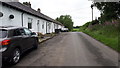
2

River Meetings
Cessnock Water and the River Irvine meetings
Image: © Scott
Taken: 27 Nov 2011
0.15 miles
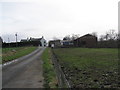

5

The River Irvine
Looking downstream between Galston and Hurlford. Accessing the bank wasn't easy with so much tall vegetation and several small flood channels.
Image: © Mary and Angus Hogg
Taken: 13 Aug 2020
0.17 miles