IMAGES TAKEN NEAR TO
KILMARNOCK, KA3 6HR
Introduction
This page details the photographs taken nearby to KA3 6HR by members of the Geograph project.
The Geograph project started in 2005 with the aim of publishing, organising and preserving representative images for every square kilometre of Great Britain, Ireland and the Isle of Man.

There are currently over 7.5m images from over14,400 individuals and you can help contribute to the project by visiting https://www.geograph.org.uk
Image Map
Images are licensed for reuse under creativecommons.org/licenses/by-sa/2.0
Notes
- Clicking on the map will re-center to the selected point.
- The higher the marker number, the further away the image location is from the centre of the postcode.
Image Listing (4 Images Found)
Images are licensed for reuse under creativecommons.org/licenses/by-sa/2.0
Image
Details
Distance
1
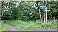
Path into the Armsheugh Plantation
Part of the Irvine Valley paths network.
Image: © Gordon Brown
Taken: 30 Jun 2020
0.18 miles
2
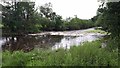
Weir on the River Irvine above Milton Mill
The river is high after two or three days of almost constant rain.
Image: © Gordon Brown
Taken: 30 Jun 2020
0.22 miles
3
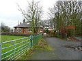
Rural housing near Templetonburn
The nearest house is called "Avondale".
Image: © Gordon Brown
Taken: 17 Dec 2014
0.23 miles
4
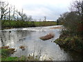
Weir on the River Irvine
Hurlford and Crookedholm Angling Club control fishing at this spot.
Image: © Gordon Brown
Taken: 17 Dec 2014
0.24 miles