IMAGES TAKEN NEAR TO
Wardlaw Road, KILMARNOCK, KA3 6HE
Introduction
This page details the photographs taken nearby to Wardlaw Road, KA3 6HE by members of the Geograph project.
The Geograph project started in 2005 with the aim of publishing, organising and preserving representative images for every square kilometre of Great Britain, Ireland and the Isle of Man.

There are currently over 7.5m images from over14,400 individuals and you can help contribute to the project by visiting https://www.geograph.org.uk
Image Map
Images are licensed for reuse under creativecommons.org/licenses/by-sa/2.0
Notes
- Clicking on the map will re-center to the selected point.
- The higher the marker number, the further away the image location is from the centre of the postcode.
Image Listing (12 Images Found)
Images are licensed for reuse under creativecommons.org/licenses/by-sa/2.0
Image
Details
Distance
1
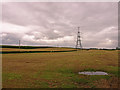
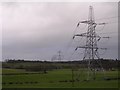
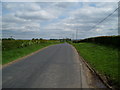
Harvested Fields near Kilmarnock
Silage has been harvested. Electricity pylon in field.
Image: © wfmillar
Taken: 7 Jun 2011
0.08 miles
2
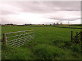
Open Field Gate
Silage field near Bringan Farm.
Image: © wfmillar
Taken: 7 Jun 2011
0.10 miles
4
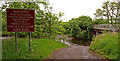
Warning Sign at Ford
Craufurdland Water, Kilmarnock.
Image: © wfmillar
Taken: 7 Jun 2011
0.16 miles
5

Footbridge over Craufurdland Water , Kilmarnock
Ford on the left.
Image: © wfmillar
Taken: 7 Jun 2011
0.18 miles
6
Craufurdland Water near Kilmarnock
Looking over the Ford. Some of the old cobbles have been exposed on the road.
Image: © wfmillar
Taken: 7 Jun 2011
0.18 miles
8

Craufurdland Water , Kilmarnock
Viewed from the ford showing the footbridge and the water pipe behind.
Image: © wfmillar
Taken: 7 Jun 2011
0.18 miles
9

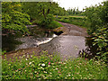
Craufurdland Water , Kilmarnock
The ford at a low water.
Image: © wfmillar
Taken: 7 Jun 2011
0.18 miles