IMAGES TAKEN NEAR TO
Fenwick, KILMARNOCK, KA3 6GL
Introduction
This page details the photographs taken nearby to KA3 6GL by members of the Geograph project.
The Geograph project started in 2005 with the aim of publishing, organising and preserving representative images for every square kilometre of Great Britain, Ireland and the Isle of Man.

There are currently over 7.5m images from over14,400 individuals and you can help contribute to the project by visiting https://www.geograph.org.uk
Image Map
Images are licensed for reuse under creativecommons.org/licenses/by-sa/2.0
Notes
- Clicking on the map will re-center to the selected point.
- The higher the marker number, the further away the image location is from the centre of the postcode.
Image Listing (7 Images Found)
Images are licensed for reuse under creativecommons.org/licenses/by-sa/2.0
Image
Details
Distance
1
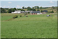
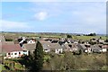
Wyllieland
The building nearest the camera does not appear on the map - it has been built recently.
Image: © Richard Sutcliffe
Taken: 25 Jul 2018
0.12 miles
4
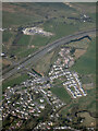
Fenwick from the air
The north end of Fenwick, by the A77 and M77 at Junction 7.
Image: © Thomas Nugent
Taken: 21 Apr 2022
0.19 miles
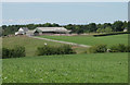
6
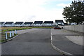
Car Park at Fenwick Cemetery
At the rear of the Cemetery. Houses are on Fowld's View.
Image: © Billy McCrorie
Taken: 29 Sep 2020
0.24 miles
7
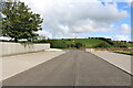
Car Park At Fenwick Cemetery
Located at the rear of the Cemetery.
Image: © Billy McCrorie
Taken: 29 Sep 2020
0.24 miles