IMAGES TAKEN NEAR TO
Brookfield Grove, KILMARNOCK, KA3 6GD
Introduction
This page details the photographs taken nearby to Brookfield Grove, KA3 6GD by members of the Geograph project.
The Geograph project started in 2005 with the aim of publishing, organising and preserving representative images for every square kilometre of Great Britain, Ireland and the Isle of Man.

There are currently over 7.5m images from over14,400 individuals and you can help contribute to the project by visiting https://www.geograph.org.uk
Image Map
Images are licensed for reuse under creativecommons.org/licenses/by-sa/2.0
Notes
- Clicking on the map will re-center to the selected point.
- The higher the marker number, the further away the image location is from the centre of the postcode.
Image Listing (19 Images Found)
Images are licensed for reuse under creativecommons.org/licenses/by-sa/2.0
Image
Details
Distance

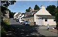
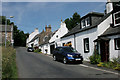
3
Waterslap, Fenwick, East Ayrshire
18th century cottages located at Waterslap, Fenwick.
Image: © Mark S
Taken: 9 Sep 2023
0.08 miles
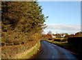
4
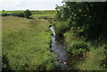
Fenwick Water
Seen from Fenwick Bridge.
Image: © Richard Sutcliffe
Taken: 25 Jul 2018
0.08 miles
8
Laigh Fenwick
The south side of Fenwick village.
Image: © Mary and Angus Hogg
Taken: 9 Nov 2006
0.14 miles
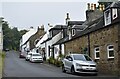
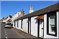
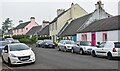
9
Main Road, Fenwick, East Ayrshire
Traditional buildings on Main Road.
Image: © Mark S
Taken: 9 Sep 2023
0.14 miles
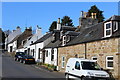
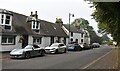
10
Main Road, Laigh Fenwick, East Ayrshire
Cottages and other traditional buildings on Main Road.
Image: © Mark S
Taken: 9 Sep 2023
0.14 miles