IMAGES TAKEN NEAR TO
Burns Way, KILMARNOCK, KA3 6GB
Introduction
This page details the photographs taken nearby to Burns Way, KA3 6GB by members of the Geograph project.
The Geograph project started in 2005 with the aim of publishing, organising and preserving representative images for every square kilometre of Great Britain, Ireland and the Isle of Man.

There are currently over 7.5m images from over14,400 individuals and you can help contribute to the project by visiting https://www.geograph.org.uk
Image Map (Loading...)


Getting Data...Please wait
Leaflet Map data © OpenStreetMap
Images are licensed for reuse under creativecommons.org/licenses/by-sa/2.0
Notes
- Clicking on the map will re-center to the selected point.
- The higher the marker number, the further away the image location is from the centre of the postcode.
Image Listing (9 Images Found)
Images are licensed for reuse under creativecommons.org/licenses/by-sa/2.0
Image
Details
Distance
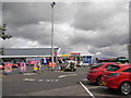
2
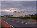
Disused Hotel, Kilmarnock
On the outskirts of the town beside the B7038.
Image: © wfmillar
Taken: 7 Jun 2011
0.16 miles

6
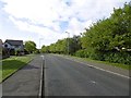
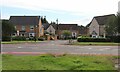
Southcraig Drive
Distribution road for a housing development off Glasgow Road, Kilmarnock.
Image: © Richard Webb
Taken: 25 Sep 2015
0.21 miles
7
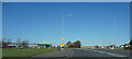
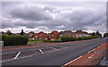
The Glasgow Road
Coming up to an island on the Glasgow Road, with very little traffic visible.
Image: © Malcolm Neal
Taken: 20 Mar 2022
0.23 miles
8
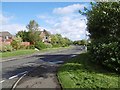
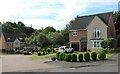
Southcraig Drive
Distribution road on a housing development which was built on the site of a farm called Southcraig.
Image: © Richard Webb
Taken: 25 Sep 2015
0.23 miles