IMAGES TAKEN NEAR TO
Glasgow Road, KILMARNOCK, KA3 6ET
Introduction
This page details the photographs taken nearby to Glasgow Road, KA3 6ET by members of the Geograph project.
The Geograph project started in 2005 with the aim of publishing, organising and preserving representative images for every square kilometre of Great Britain, Ireland and the Isle of Man.

There are currently over 7.5m images from over14,400 individuals and you can help contribute to the project by visiting https://www.geograph.org.uk
Image Map
Images are licensed for reuse under creativecommons.org/licenses/by-sa/2.0
Notes
- Clicking on the map will re-center to the selected point.
- The higher the marker number, the further away the image location is from the centre of the postcode.
Image Listing (4 Images Found)
Images are licensed for reuse under creativecommons.org/licenses/by-sa/2.0
Image
Details
Distance
1
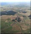
The M77 at Tam's Hill from the air
Tam's Hill is in the lower left corner. The M77 crosses over the A77 at this point.
Image: © Thomas Nugent
Taken: 7 Apr 2022
0.16 miles
2
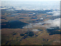
The M77 and A77 from the air
The roads cross at Junction 6, near Tam's Hill. Drumtee Farm is in the right foreground.
Image: © Thomas Nugent
Taken: 16 Mar 2016
0.18 miles