IMAGES TAKEN NEAR TO
Fenwick, KILMARNOCK, KA3 6ER
Introduction
This page details the photographs taken nearby to KA3 6ER by members of the Geograph project.
The Geograph project started in 2005 with the aim of publishing, organising and preserving representative images for every square kilometre of Great Britain, Ireland and the Isle of Man.

There are currently over 7.5m images from over14,400 individuals and you can help contribute to the project by visiting https://www.geograph.org.uk
Image Map
Images are licensed for reuse under creativecommons.org/licenses/by-sa/2.0
Notes
- Clicking on the map will re-center to the selected point.
- The higher the marker number, the further away the image location is from the centre of the postcode.
Image Listing (12 Images Found)
Images are licensed for reuse under creativecommons.org/licenses/by-sa/2.0
Image
Details
Distance
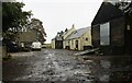
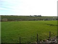
3
North Glassock
A farm which has found itself beside the M77 motorway.
Image: © Richard Webb
Taken: 25 Sep 2015
0.09 miles
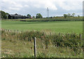
5
Across the M77
Glassock farm in the distance.
Image: © Gordon Brown
Taken: 15 Feb 2008
0.12 miles
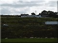
6
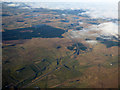
The M77 and A77 from the air
The roads cross at Junction 6, near Tam's Hill.
Image: © Thomas Nugent
Taken: 16 Mar 2016
0.14 miles
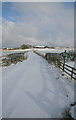
7
Road to North Glassock Boarding Kennels
Image: © Richard Sutcliffe
Taken: 25 Jul 2018
0.14 miles
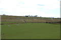
9
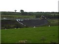
Embankment work on the M77
Rebuilding the face of a motorway embankment.
Image: © Richard Webb
Taken: 25 Sep 2015
0.20 miles
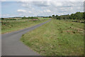
10
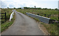
Bridge over drainage ditch near North Glassock Boarding Kennels
This is a short one-way section of road which joins onto the A719, close to where the van is passing.
Image: © Richard Sutcliffe
Taken: 25 Jul 2018
0.21 miles