IMAGES TAKEN NEAR TO
Skernieland Road, KILMARNOCK, KA3 6EQ
Introduction
This page details the photographs taken nearby to Skernieland Road, KA3 6EQ by members of the Geograph project.
The Geograph project started in 2005 with the aim of publishing, organising and preserving representative images for every square kilometre of Great Britain, Ireland and the Isle of Man.

There are currently over 7.5m images from over14,400 individuals and you can help contribute to the project by visiting https://www.geograph.org.uk
Image Map
Images are licensed for reuse under creativecommons.org/licenses/by-sa/2.0
Notes
- Clicking on the map will re-center to the selected point.
- The higher the marker number, the further away the image location is from the centre of the postcode.
Image Listing (109 Images Found)
Images are licensed for reuse under creativecommons.org/licenses/by-sa/2.0
Image
Details
Distance
1
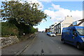
Skernieland Road, Fenwick
Leads to the Village Cemetery.
Image: © Billy McCrorie
Taken: 29 Sep 2020
0.02 miles
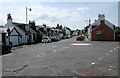
2
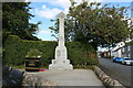
Fenwick War Memorial
On the right is Skernieland Road.
Image: © Billy McCrorie
Taken: 29 Sep 2020
0.04 miles
3
Skernieland Road, Fenwick
War Memorial at the junction of Skernieland Road, Stewarton Road and Main Road [B751].
Image: © M J Richardson
Taken: 26 Jun 2013
0.04 miles

5
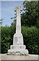
War memorial, Fenwick
ERECTED
IN MEMORY OF
THE GALLANT MEN
OF FENWICK DISTRICT
WHO GAVE THEIR LIVES
FOR THEIR COUNTRY
IN THE GREAT WARS
Image: © Richard Sutcliffe
Taken: 25 Jul 2018
0.05 miles
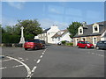
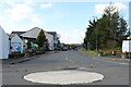
6
Roundabout, Fenwick
Looking down Main Road, Fenwick (B751) from the war memorial.
Image: © Richard Sutcliffe
Taken: 25 Jul 2018
0.06 miles
7
Stewarton Road, Fenwick
About to pass under the M77.
Image: © Billy McCrorie
Taken: 29 Sep 2020
0.07 miles
8
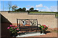
Fenwick Cemetery
Located at Skernieland Road with car park at rear of Cemetery. With memorial seat.
Image: © Billy McCrorie
Taken: 29 Sep 2020
0.08 miles
9
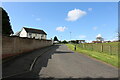
Skernieland Road, Fenwick
Exit road from the Cemetery.
Image: © Billy McCrorie
Taken: 29 Sep 2020
0.08 miles
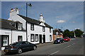
10
101-103 Main Road, Fenwick
The Category C listed building has a date of 1824 on the raised attic gable. Fenwick's war memorial [http://www.geograph.org.uk/photo/5854049] can be seen in the distance.
Image: © Richard Sutcliffe
Taken: 25 Jul 2018
0.08 miles