IMAGES TAKEN NEAR TO
Fenwick, KILMARNOCK, KA3 6BZ
Introduction
This page details the photographs taken nearby to KA3 6BZ by members of the Geograph project.
The Geograph project started in 2005 with the aim of publishing, organising and preserving representative images for every square kilometre of Great Britain, Ireland and the Isle of Man.

There are currently over 7.5m images from over14,400 individuals and you can help contribute to the project by visiting https://www.geograph.org.uk
Image Map
Images are licensed for reuse under creativecommons.org/licenses/by-sa/2.0
Notes
- Clicking on the map will re-center to the selected point.
- The higher the marker number, the further away the image location is from the centre of the postcode.
Image Listing (4 Images Found)
Images are licensed for reuse under creativecommons.org/licenses/by-sa/2.0
Image
Details
Distance
1
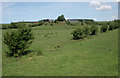
Farmland south of Bruntland Farm
The farm is in the distance.
Image: © Richard Sutcliffe
Taken: 25 Jul 2018
0.18 miles
2
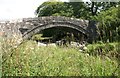
Bruntland Bridge
Category B listed bridge over the Crawfurdland Water, dating from 1793. Part of the parapet has recently been repaired. The wooden pallets under the bridge appear to be placed there to stop any floating debris being carried downstream.
Image: © Richard Sutcliffe
Taken: 25 Jul 2018
0.21 miles
3
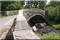
Bruntland Bridge
Category B listed bridge over the Crawfurdland Water, dating from 1793. Part of the parapet has recently been repaired. The wooden pallets under the bridge appear to be placed there to stop any floating debris being carried downstream. They are not really required at this time, as the water level is very low.
Image: © Richard Sutcliffe
Taken: 25 Jul 2018
0.21 miles
4
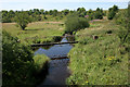
Pipe crossing the Crawfurdland Water
Seen from Bruntland Bridge.
Image: © Richard Sutcliffe
Taken: 25 Jul 2018
0.22 miles