IMAGES TAKEN NEAR TO
Fenwick, KILMARNOCK, KA3 6BY
Introduction
This page details the photographs taken nearby to KA3 6BY by members of the Geograph project.
The Geograph project started in 2005 with the aim of publishing, organising and preserving representative images for every square kilometre of Great Britain, Ireland and the Isle of Man.

There are currently over 7.5m images from over14,400 individuals and you can help contribute to the project by visiting https://www.geograph.org.uk
Image Map
Images are licensed for reuse under creativecommons.org/licenses/by-sa/2.0
Notes
- Clicking on the map will re-center to the selected point.
- The higher the marker number, the further away the image location is from the centre of the postcode.
Image Listing (5 Images Found)
Images are licensed for reuse under creativecommons.org/licenses/by-sa/2.0
Image
Details
Distance
1
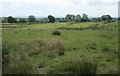
Midland Farm, Fenwick
In 1685, a party of dragoons interrupted a prayer meeting at Midland Farm, attended by Covenanters John Nisbet, Peter Gemmel, George Woodburn and John Fergushill. They searched the house for an hour, but, finding nothing, gave up their search. They were told shortly afterwards, however, that they were ‘good seekers, but ill finders,’ and this prompted them to return to the farm where they found the Covenanters hiding in the barn with the cattle.
Peter Gemmel, George Woodburn and John Fergushill were shot to death. John Nisbet was wounded, but survived. He was later executed at Kilmarnock.
Image: © Becky Williamson
Taken: 13 Feb 2011
0.02 miles
3
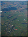
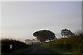
Fenwick and the M77 from the air
Fenwick is at the south end of the M77 motorway which connects Glasgow and the central belt with Kilmarnock and south Ayrshire.
Image: © Thomas Nugent
Taken: 25 Sep 2017
0.19 miles