IMAGES TAKEN NEAR TO
Fenwick, KILMARNOCK, KA3 6BD
Introduction
This page details the photographs taken nearby to KA3 6BD by members of the Geograph project.
The Geograph project started in 2005 with the aim of publishing, organising and preserving representative images for every square kilometre of Great Britain, Ireland and the Isle of Man.

There are currently over 7.5m images from over14,400 individuals and you can help contribute to the project by visiting https://www.geograph.org.uk
Image Map
Images are licensed for reuse under creativecommons.org/licenses/by-sa/2.0
Notes
- Clicking on the map will re-center to the selected point.
- The higher the marker number, the further away the image location is from the centre of the postcode.
Image Listing (6 Images Found)
Images are licensed for reuse under creativecommons.org/licenses/by-sa/2.0
Image
Details
Distance
1
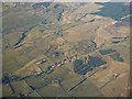
The Swinzie Burn from the air
East Broadmoss farm is in the foreground.
Image: © Thomas Nugent
Taken: 16 Mar 2016
0.11 miles
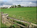
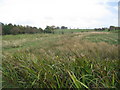
4
East Broadmoss.
East Broadmoss can be seen in the trees.
Image: © wfmillar
Taken: 20 Oct 2006
0.23 miles
6
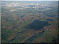
Glenouther Moor from the air
With several lochs and reservoirs beyond and the Glasgow conurbation in the distance.
Image: © Thomas Nugent
Taken: 3 Dec 2018
0.23 miles