IMAGES TAKEN NEAR TO
Ostler Place, KILMARNOCK, KA3 5QS
Introduction
This page details the photographs taken nearby to Ostler Place, KA3 5QS by members of the Geograph project.
The Geograph project started in 2005 with the aim of publishing, organising and preserving representative images for every square kilometre of Great Britain, Ireland and the Isle of Man.

There are currently over 7.5m images from over14,400 individuals and you can help contribute to the project by visiting https://www.geograph.org.uk
Image Map
Images are licensed for reuse under creativecommons.org/licenses/by-sa/2.0
Notes
- Clicking on the map will re-center to the selected point.
- The higher the marker number, the further away the image location is from the centre of the postcode.
Image Listing (7 Images Found)
Images are licensed for reuse under creativecommons.org/licenses/by-sa/2.0
Image
Details
Distance
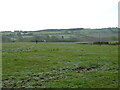
1
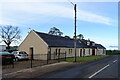
Cottages on the Old Glasgow Road, Causeyhead
Image: © JThomas
Taken: 24 May 2021
0.15 miles
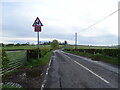
2
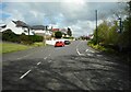
Old Glasgow Road
On the outskirts of Stewarton.
Image: © Richard Sutcliffe
Taken: 5 May 2023
0.16 miles
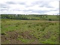
4
Old Glasgow Road
On the edge of Stewarton.
This view is similar to the first image for this square Image taken and submitted in 2006.
Image: © Richard Sutcliffe
Taken: 5 May 2023
0.20 miles
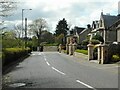
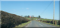
6
Old Glasgow Road (B769), Causeyhead
Towards Glasgow.
Image: © JThomas
Taken: 24 May 2021
0.23 miles
7
Old Glasgow Road
The B769 or the Old Glasgow Road is the road we took out of Stewarton. The day is still very bright with a cloudless sky.
Image: © Malcolm Neal
Taken: 20 Mar 2022
0.23 miles