IMAGES TAKEN NEAR TO
Bowes Rigg, KILMARNOCK, KA3 5NA
Introduction
This page details the photographs taken nearby to Bowes Rigg, KA3 5NA by members of the Geograph project.
The Geograph project started in 2005 with the aim of publishing, organising and preserving representative images for every square kilometre of Great Britain, Ireland and the Isle of Man.

There are currently over 7.5m images from over14,400 individuals and you can help contribute to the project by visiting https://www.geograph.org.uk
Image Map
Images are licensed for reuse under creativecommons.org/licenses/by-sa/2.0
Notes
- Clicking on the map will re-center to the selected point.
- The higher the marker number, the further away the image location is from the centre of the postcode.
Image Listing (5 Images Found)
Images are licensed for reuse under creativecommons.org/licenses/by-sa/2.0
Image
Details
Distance
1
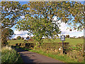
Private Road near Stewarton
Leading to Meikle Corsehill eventually.
Image: © wfmillar
Taken: 7 Oct 2010
0.12 miles
2
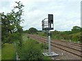
Railway signal
A light signal on the Kilmarnock to Glasgow railway line near Stewarton.
Image: © James Allan
Taken: 24 Jun 2010
0.21 miles
3
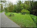
Picnic tables and seats
In Cunningham Watt Park. It is probably best to use the tables on the right, nearest the burn. The ones nearest the path are under tree branches and are covered with bird droppings!
Image: © Richard Sutcliffe
Taken: 5 May 2023
0.23 miles
5
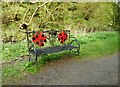
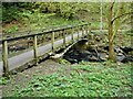
Seat beside the Clerkland Burn
With ladybird-like decoration.
Image: © Richard Sutcliffe
Taken: 5 May 2023
0.24 miles