IMAGES TAKEN NEAR TO
Stewarton, KILMARNOCK, KA3 5LB
Introduction
This page details the photographs taken nearby to KA3 5LB by members of the Geograph project.
The Geograph project started in 2005 with the aim of publishing, organising and preserving representative images for every square kilometre of Great Britain, Ireland and the Isle of Man.

There are currently over 7.5m images from over14,400 individuals and you can help contribute to the project by visiting https://www.geograph.org.uk
Image Map
Images are licensed for reuse under creativecommons.org/licenses/by-sa/2.0
Notes
- Clicking on the map will re-center to the selected point.
- The higher the marker number, the further away the image location is from the centre of the postcode.
Image Listing (8 Images Found)
Images are licensed for reuse under creativecommons.org/licenses/by-sa/2.0
Image
Details
Distance
3
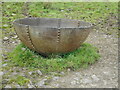
Steel Trough
Probably the same one photographed nearby in 2006 Image
Image: © Richard Sutcliffe
Taken: 5 May 2023
0.03 miles
5
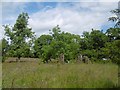
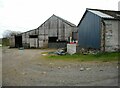
Townend of Gabrochill
A ruined farm, named on the 1898 6" map.
Image: © Richard Webb
Taken: 25 Jun 2016
0.15 miles
6
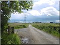
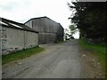
Road to Greensland
Passing the ruins of Townend of Gabrochill.
Image: © Richard Webb
Taken: 25 Jun 2016
0.17 miles
7
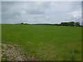
Improved pasture, Gabroc Hill
Grassland at over 200m above sea level.
Image: © Richard Webb
Taken: 25 Jun 2016
0.19 miles
8
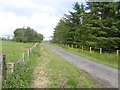
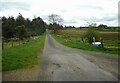
Dunlop to Neilston hill road
On Gabroc Hill.
Image: © Richard Webb
Taken: 25 Jun 2016
0.21 miles