IMAGES TAKEN NEAR TO
Stewarton, KILMARNOCK, KA3 5JZ
Introduction
This page details the photographs taken nearby to KA3 5JZ by members of the Geograph project.
The Geograph project started in 2005 with the aim of publishing, organising and preserving representative images for every square kilometre of Great Britain, Ireland and the Isle of Man.

There are currently over 7.5m images from over14,400 individuals and you can help contribute to the project by visiting https://www.geograph.org.uk
Image Map
Images are licensed for reuse under creativecommons.org/licenses/by-sa/2.0
Notes
- Clicking on the map will re-center to the selected point.
- The higher the marker number, the further away the image location is from the centre of the postcode.
Image Listing (7 Images Found)
Images are licensed for reuse under creativecommons.org/licenses/by-sa/2.0
Image
Details
Distance
1
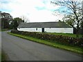
Townend of Fullwood
One side of the farmhouse at Townend of Fullwood.
Image: © Richard Sutcliffe
Taken: 5 May 2023
0.05 miles
2
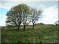
Three trees
Beside Harelaw Road at Townend of Fullwood.
Image: © Richard Sutcliffe
Taken: 5 May 2023
0.08 miles
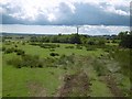
3
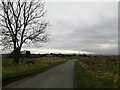
Minor roads near Fullwood
To the right round the corner the road heads for Dunlop, meeting the road that comes south from Neilston. The turning to the left, just after the tree, takes another minor road in the Stewarton direction.
Image: © Alec MacKinnon
Taken: 22 Mar 2021
0.09 miles
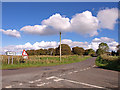
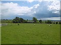
6
Fullwood
Southward view off a small hill. There were some unpleasant looking showers about.
Image: © Richard Webb
Taken: 25 Jun 2016
0.21 miles
7
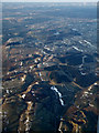
Townened of Fulwood from the air
The disused quarry opposite Craignaught Farm Image can be seen in the lower right corner.
Image: © Thomas Nugent
Taken: 29 Mar 2013
0.23 miles