IMAGES TAKEN NEAR TO
Kingsford, KILMARNOCK, KA3 5JS
Introduction
This page details the photographs taken nearby to Kingsford, KA3 5JS by members of the Geograph project.
The Geograph project started in 2005 with the aim of publishing, organising and preserving representative images for every square kilometre of Great Britain, Ireland and the Isle of Man.

There are currently over 7.5m images from over14,400 individuals and you can help contribute to the project by visiting https://www.geograph.org.uk
Image Map
Images are licensed for reuse under creativecommons.org/licenses/by-sa/2.0
Notes
- Clicking on the map will re-center to the selected point.
- The higher the marker number, the further away the image location is from the centre of the postcode.
Image Listing (11 Images Found)
Images are licensed for reuse under creativecommons.org/licenses/by-sa/2.0
Image
Details
Distance
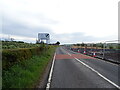
1
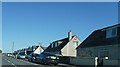
The B769
Just passing Kingsford, a group of just a few houses on the B769.
Image: © Malcolm Neal
Taken: 20 Mar 2022
0.02 miles
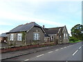
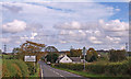
2
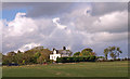
Roadside houses
In the hamlet of Kingsford on the B769.
Image: © James Allan
Taken: 1 Jun 2012
0.02 miles
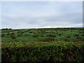
8
The B769
Empty fields on both sides of the B769.
Image: © Malcolm Neal
Taken: 20 Mar 2022
0.17 miles
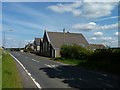
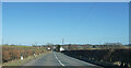
9

B769 at East Spittal
The picture looks along the road in the Stewarton direction as it approaches Kingsford, site of recent house building (Image).
Image: © Alec MacKinnon
Taken: 3 Oct 2022
0.18 miles
10
High Williamshaw
View across farmland from near Kingsford.
Image: © wfmillar
Taken: 7 Oct 2010
0.20 miles