IMAGES TAKEN NEAR TO
Stewarton, KILMARNOCK, KA3 5JE
Introduction
This page details the photographs taken nearby to KA3 5JE by members of the Geograph project.
The Geograph project started in 2005 with the aim of publishing, organising and preserving representative images for every square kilometre of Great Britain, Ireland and the Isle of Man.

There are currently over 7.5m images from over14,400 individuals and you can help contribute to the project by visiting https://www.geograph.org.uk
Image Map
Images are licensed for reuse under creativecommons.org/licenses/by-sa/2.0
Notes
- Clicking on the map will re-center to the selected point.
- The higher the marker number, the further away the image location is from the centre of the postcode.
Image Listing (5 Images Found)
Images are licensed for reuse under creativecommons.org/licenses/by-sa/2.0
Image
Details
Distance
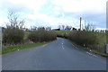
1
B778 leaving Stewarton
Good advice on this twisty road.
Image: © wfmillar
Taken: 7 Oct 2010
0.12 miles
2
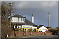
Cottage east of Little Cutstraw
On a sharp bend in the road
Image: © Leslie Barrie
Taken: 23 Mar 2014
0.12 miles
3
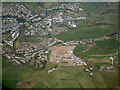
Stewarton from the air
Draffen park housing estate is under construction at Waterhead on the B778 at the east side of the town.
Image: © Thomas Nugent
Taken: 21 Apr 2022
0.14 miles
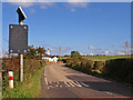
4
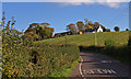
B778 leaving Stewarton
Houses at Little Cutstraw on the hill.
Image: © wfmillar
Taken: 7 Oct 2010
0.17 miles