IMAGES TAKEN NEAR TO
Kersland Gait, KILMARNOCK, KA3 5HN
Introduction
This page details the photographs taken nearby to Kersland Gait, KA3 5HN by members of the Geograph project.
The Geograph project started in 2005 with the aim of publishing, organising and preserving representative images for every square kilometre of Great Britain, Ireland and the Isle of Man.

There are currently over 7.5m images from over14,400 individuals and you can help contribute to the project by visiting https://www.geograph.org.uk
Image Map
Images are licensed for reuse under creativecommons.org/licenses/by-sa/2.0
Notes
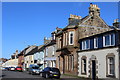
- Clicking on the map will re-center to the selected point.
- The higher the marker number, the further away the image location is from the centre of the postcode.
Image Listing (113 Images Found)
Images are licensed for reuse under creativecommons.org/licenses/by-sa/2.0
Image
Details
Distance
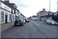
3
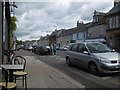
High Street, Stewarton
View from a cafe.
Image: © Richard Webb
Taken: 25 Jun 2016
0.05 miles
4
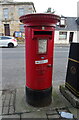
Elizabethan postbox on High Street, Stewarton
Postbox No. KA3 300.
Image: © JThomas
Taken: 23 May 2021
0.05 miles
6
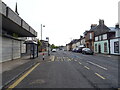
Bus stop and shelter on High Street (B769), Stewarton
Image: © JThomas
Taken: 23 May 2021
0.06 miles
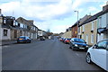
9
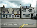
Businesses on Main Street
Roxburgh Group (insurance brokers), Rootz (hair salon) and Coffee Pot (coffee shop) on Main Street, Stewarton.
Image: © Richard Sutcliffe
Taken: 5 May 2023
0.07 miles
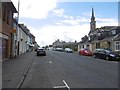
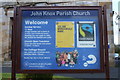
10
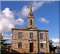
John Knox Church, Stewarton
Sits on High Street (B778), Stewarton.
Image: © wfmillar
Taken: 7 Oct 2010
0.07 miles