IMAGES TAKEN NEAR TO
Armour Place, KILMARNOCK, KA3 5EZ
Introduction
This page details the photographs taken nearby to Armour Place, KA3 5EZ by members of the Geograph project.
The Geograph project started in 2005 with the aim of publishing, organising and preserving representative images for every square kilometre of Great Britain, Ireland and the Isle of Man.

There are currently over 7.5m images from over14,400 individuals and you can help contribute to the project by visiting https://www.geograph.org.uk
Image Map
Images are licensed for reuse under creativecommons.org/licenses/by-sa/2.0
Notes
- Clicking on the map will re-center to the selected point.
- The higher the marker number, the further away the image location is from the centre of the postcode.
Image Listing (109 Images Found)
Images are licensed for reuse under creativecommons.org/licenses/by-sa/2.0
Image
Details
Distance
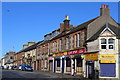
1

Dunlop Street
Quite a wide street in Stewarton.
Image: © Malcolm Neal
Taken: 20 Mar 2022
0.03 miles
2
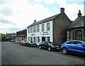
Businesses on Dunlop Street
Physioflexx Ayrshire (a private physiotherapy service) and Buchanan Private Label (a distribution service) on Dunlop Street, Stewarton.
Image: © Richard Sutcliffe
Taken: 5 May 2023
0.04 miles
6
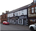
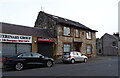
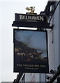
The Smugglers Inn, Stewarton
On High Street (B769).
Image: © JThomas
Taken: 23 May 2021
0.05 miles
8
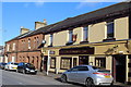
The Smugglers Inn, High Street, Stewarton
Image: © Leslie Barrie
Taken: 23 Mar 2014
0.05 miles
9
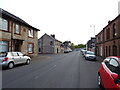
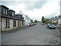
High Street (B769), Stewarton
Heading north east from town.
Image: © JThomas
Taken: 23 May 2021
0.06 miles
10
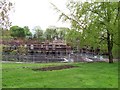
Building site
One of several large housing developments currently under way in Stewarton.
Image: © Thomas Nugent
Taken: 16 May 2006
0.06 miles