IMAGES TAKEN NEAR TO
Kirk Glebe, KILMARNOCK, KA3 5BJ
Introduction
This page details the photographs taken nearby to Kirk Glebe, KA3 5BJ by members of the Geograph project.
The Geograph project started in 2005 with the aim of publishing, organising and preserving representative images for every square kilometre of Great Britain, Ireland and the Isle of Man.

There are currently over 7.5m images from over14,400 individuals and you can help contribute to the project by visiting https://www.geograph.org.uk
Image Map
Images are licensed for reuse under creativecommons.org/licenses/by-sa/2.0
Notes
- Clicking on the map will re-center to the selected point.
- The higher the marker number, the further away the image location is from the centre of the postcode.
Image Listing (83 Images Found)
Images are licensed for reuse under creativecommons.org/licenses/by-sa/2.0
Image
Details
Distance
1
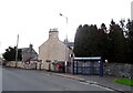
Bus stop and shelter on Lainshaw Street, Stewarton
Showing position of Postbox No. KA3 60.
See Image] for postbox.
Image: © JThomas
Taken: 23 May 2021
0.05 miles
2
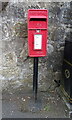
Elizabethan postbox on Lainshaw Street, Stewarton
Postbox No. KA3 60.
See Image] for context.
Image: © JThomas
Taken: 23 May 2021
0.05 miles
3
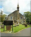
St. Columba's Parish Church
A Category B listed church https://portal.historicenvironment.scot/designation/LB41063 dating from 1696, with later alterations, resulting in the off-centre bell tower.
Image: © Richard Sutcliffe
Taken: 5 May 2023
0.06 miles
4
St. Columba's Parish Church
A Category B listed church https://portal.historicenvironment.scot/designation/LB41063 dating from 1696, with later alterations, resulting in the off-centre bell tower.
Image: © Richard Sutcliffe
Taken: 5 May 2023
0.06 miles
5
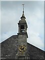
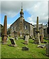
Bell tower
The bell tower of St Columba's Church is off centre due to alterations and extensions to the church over the years. The Category B listed church https://portal.historicenvironment.scot/designation/LB41063 dates from 1696. The clock commemorates Queen Victoria's jubilee in 1887.
Image: © Richard Sutcliffe
Taken: 5 May 2023
0.06 miles
6
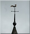
Weather vane, St Columba's Church
The church is Category B listed https://portal.historicenvironment.scot/designation/LB41063 dating from 1696.
Image: © Richard Sutcliffe
Taken: 5 May 2023
0.06 miles
7
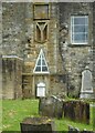
Unusual features, St Columba's Church
The Y fork on the bell-tower represents the motto of the Cunninghams 'over fork over' . The legend describes how Malcolm Canmore was fleeing south from Macbeth, King of Scotland who wanted to kill him. Malcolm took refuge in a barn at the estate of Corsehill, just outside Stewarton and called to the farmer to 'over fork over' and the farmer covered him with hay and Macbeth did not find him. (See https://portal.historicenvironment.scot/designation/LB41063). The triangular window below is also an unusual feature to find in a church.
Image: © Richard Sutcliffe
Taken: 5 May 2023
0.06 miles
8
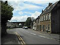
Lainshaw Street
Looking towards the Category B railway viaduct https://portal.historicenvironment.scot/designation/LB41074, which crosses the Annick Water and Lainshaw Street. The building on the right was once a knitwear factory https://canmore.org.uk/site/173552/stewarton-69-71-lainshaw-street-knitwear-factory.
Image: © Richard Sutcliffe
Taken: 5 May 2023
0.06 miles
9
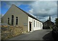
Church Hall
The church hall for St Columba's Parish Church (in the distance), just off Lainshaw Street.
Image: © Richard Sutcliffe
Taken: 5 May 2023
0.06 miles
10
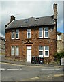
House on Lainshaw Street
Constructed from red sandstone.
Image: © Richard Sutcliffe
Taken: 5 May 2023
0.07 miles