IMAGES TAKEN NEAR TO
Main Street, KILMARNOCK, KA3 5AE
Introduction
This page details the photographs taken nearby to Main Street, KA3 5AE by members of the Geograph project.
The Geograph project started in 2005 with the aim of publishing, organising and preserving representative images for every square kilometre of Great Britain, Ireland and the Isle of Man.

There are currently over 7.5m images from over14,400 individuals and you can help contribute to the project by visiting https://www.geograph.org.uk
Image Map
Images are licensed for reuse under creativecommons.org/licenses/by-sa/2.0
Notes
- Clicking on the map will re-center to the selected point.
- The higher the marker number, the further away the image location is from the centre of the postcode.
Image Listing (111 Images Found)
Images are licensed for reuse under creativecommons.org/licenses/by-sa/2.0
Image
Details
Distance
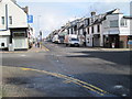
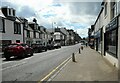
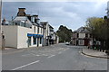
2
Businesses on Main Street
Roxburgh Group (insurance brokers), Rootz (hair salon) and Coffee Pot (coffee shop) on Main Street, Stewarton.
Image: © Richard Sutcliffe
Taken: 5 May 2023
0.02 miles
4
The Chip Box, Rigg Street, Stewarton
Award winning fish & chip shop
Image: © Leslie Barrie
Taken: 23 Mar 2014
0.03 miles
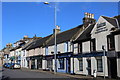
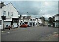
5
Main Street, Stewarton
Looking towards the Cross.
Image: © Richard Sutcliffe
Taken: 5 May 2023
0.03 miles
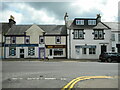
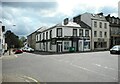
6
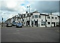
The Cross, Stewarton
The Deli at One occupies the corner property which is 1 Vennel Street.
Image: © Richard Sutcliffe
Taken: 5 May 2023
0.03 miles
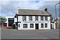
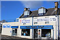
10
The Cross, Stewarton
Meenas Fine Indian occupies the building at the corner of Lainshaw Street and Vennel Street. Originally built about 1840, it is Category C listed https://portal.historicenvironment.scot/designation/LB49114. The building to the right is relatively new having been built sometime between 2011 and 2018 (judging by images on Google Street View).
This view is similar to the first image for this square Image taken and submitted in 2006, which shows the gap site that was there previously.
Image: © Richard Sutcliffe
Taken: 5 May 2023
0.04 miles