IMAGES TAKEN NEAR TO
Avenue Square, KILMARNOCK, KA3 5AB
Introduction
This page details the photographs taken nearby to Avenue Square, KA3 5AB by members of the Geograph project.
The Geograph project started in 2005 with the aim of publishing, organising and preserving representative images for every square kilometre of Great Britain, Ireland and the Isle of Man.

There are currently over 7.5m images from over14,400 individuals and you can help contribute to the project by visiting https://www.geograph.org.uk
Image Map
Images are licensed for reuse under creativecommons.org/licenses/by-sa/2.0
Notes
- Clicking on the map will re-center to the selected point.
- The higher the marker number, the further away the image location is from the centre of the postcode.
Image Listing (114 Images Found)
Images are licensed for reuse under creativecommons.org/licenses/by-sa/2.0
Image
Details
Distance
1
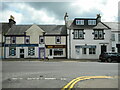
The Stewarton Arms
Public house in Avenue Square, Stewarton.
Image: © Richard Sutcliffe
Taken: 5 May 2023
0.02 miles
2
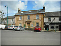
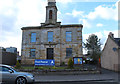
The Town House
In Avenue Square. The Category C listed https://portal.historicenvironment.scot/designation/LB41067 former burgh offices are mid-19th century in date. The building is now a sub-office of East Ayrshire Council.
Image: © Richard Sutcliffe
Taken: 5 May 2023
0.02 miles
3
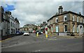
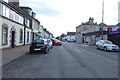
Avenue Square
Looking across the B769 towards the Institute Hall. The building on the right is the Category C listed former Bank of Scotland https://portal.historicenvironment.scot/designation/LB41068, now Gilmartins, a cafe and bakery.
Image: © Richard Sutcliffe
Taken: 5 May 2023
0.03 miles
4
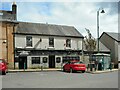
Businesses on Main Street
Roxburgh Group (insurance brokers), Rootz (hair salon) and Coffee Pot (coffee shop) on Main Street, Stewarton.
Image: © Richard Sutcliffe
Taken: 5 May 2023
0.03 miles
5
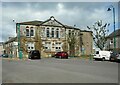
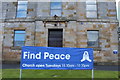
Institute Hall
A 19th century civic building comprising public halls with library, but it was deemed surplus to requirements by the local council in 2010. It is currently for sale with planning permission for 6 flats. It is in the Buildings at Risk Register https://www.buildingsatrisk.org.uk/details/914619.
Image: © Richard Sutcliffe
Taken: 5 May 2023
0.03 miles
6
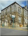
Institute Hall
A 19th century civic building comprising public halls with library, but it was deemed surplus to requirements by the local council in 2010. It is currently for sale with planning permission for 6 flats. It is in the Buildings at Risk Register https://www.buildingsatrisk.org.uk/details/914619.
Image: © Richard Sutcliffe
Taken: 5 May 2023
0.03 miles
7
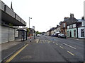
Bus stop and shelter on High Street (B769), Stewarton
Image: © JThomas
Taken: 23 May 2021
0.04 miles