IMAGES TAKEN NEAR TO
Dunlop, KILMARNOCK, KA3 4EY
Introduction
This page details the photographs taken nearby to KA3 4EY by members of the Geograph project.
The Geograph project started in 2005 with the aim of publishing, organising and preserving representative images for every square kilometre of Great Britain, Ireland and the Isle of Man.

There are currently over 7.5m images from over14,400 individuals and you can help contribute to the project by visiting https://www.geograph.org.uk
Image Map
Images are licensed for reuse under creativecommons.org/licenses/by-sa/2.0
Notes
- Clicking on the map will re-center to the selected point.
- The higher the marker number, the further away the image location is from the centre of the postcode.
Image Listing (7 Images Found)
Images are licensed for reuse under creativecommons.org/licenses/by-sa/2.0
Image
Details
Distance
1
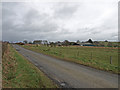
Hazelbank Farm
Minor road runs past Hazelbank. Looks like the farm is now used mainly for horses.
Image: © wfmillar
Taken: 27 Mar 2009
0.04 miles
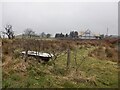
3
By Hazelbank
A field corner north of Dunlop. I was given a dire warning by a farmer about hedge trimmings and probably punctures around here, but a lot of the hedges were beech.
Image: © Richard Webb
Taken: 6 Nov 2016
0.08 miles
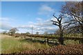
4

Halket Road at the crossroads
We look roughly West along the road to Halket from the crossroads. The road to the left heads for Dunlop, to the right towards Uplawmoor.
Image: © Alec MacKinnon
Taken: 19 Jul 2023
0.09 miles
5
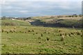
Field by Hazelbank
View towards a cleuch carrying the Glazart Burn.
Image: © Richard Webb
Taken: 6 Nov 2016
0.18 miles
6
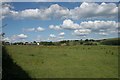
Farmland near Hazelbank Farm
The farm buildings are in the distance.
Image: © Richard Sutcliffe
Taken: 19 Jul 2016
0.22 miles
7
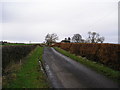
Roadside Hedges
On the left Hawthorn on the right Beech, looking north along the minor road to Fingart.
Image: © Chris Court
Taken: 12 Nov 2005
0.23 miles