IMAGES TAKEN NEAR TO
Halket Road, KILMARNOCK, KA3 4EE
Introduction
This page details the photographs taken nearby to Halket Road, KA3 4EE by members of the Geograph project.
The Geograph project started in 2005 with the aim of publishing, organising and preserving representative images for every square kilometre of Great Britain, Ireland and the Isle of Man.

There are currently over 7.5m images from over14,400 individuals and you can help contribute to the project by visiting https://www.geograph.org.uk
Image Map
Images are licensed for reuse under creativecommons.org/licenses/by-sa/2.0
Notes
- Clicking on the map will re-center to the selected point.
- The higher the marker number, the further away the image location is from the centre of the postcode.
Image Listing (4 Images Found)
Images are licensed for reuse under creativecommons.org/licenses/by-sa/2.0
Image
Details
Distance
1
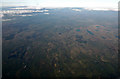
Lugton from the air
Lugton is in the lower left quadrant, with Uplawmoor and Neilston are also visible further along the Glasgow to Kilmarnock railway line.
Image: © Thomas Nugent
Taken: 18 Mar 2015
0.09 miles
2
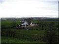
Smoking Chimneys
Smell the woodsmoke! view of North Halket and nearby houses.
Image: © Chris Court
Taken: 12 Nov 2005
0.10 miles
3
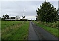
Roads meet at Halket
The road in the foreground arrives at this point from Uplawmoor. The junction with another minor road running east-west can be spotted to the right of the house, most westerly of the group of houses at Halket.
Image: © Alec MacKinnon
Taken: 8 Sep 2022
0.21 miles
4
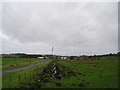
Drainage Ditch
Newly excavated drainage ditch at side of road to Dunniflat farm.
Image: © Chris Court
Taken: 12 Nov 2005
0.25 miles