IMAGES TAKEN NEAR TO
Burnside Cottages, KILMARNOCK, KA3 4DY
Introduction
This page details the photographs taken nearby to Burnside Cottages, KA3 4DY by members of the Geograph project.
The Geograph project started in 2005 with the aim of publishing, organising and preserving representative images for every square kilometre of Great Britain, Ireland and the Isle of Man.

There are currently over 7.5m images from over14,400 individuals and you can help contribute to the project by visiting https://www.geograph.org.uk
Image Map
Images are licensed for reuse under creativecommons.org/licenses/by-sa/2.0
Notes
- Clicking on the map will re-center to the selected point.
- The higher the marker number, the further away the image location is from the centre of the postcode.
Image Listing (45 Images Found)
Images are licensed for reuse under creativecommons.org/licenses/by-sa/2.0
Image
Details
Distance
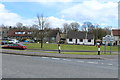
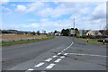
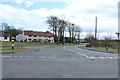
3
Rainy day in Lugton
Looking east from Dunlop Road towards Burnside Cottages.
Image: © Richard Dorrell
Taken: 11 Aug 2021
0.04 miles
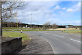
4
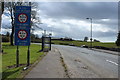
A735 at Lugton
With low bridges warning signs.
Image: © Billy McCrorie
Taken: 25 Apr 2016
0.05 miles
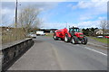
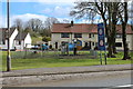
8
Tractor rally, Lugton
Several old tractors turned into Dunlop Road.
Image: © Richard Webb
Taken: 9 Sep 2017
0.05 miles
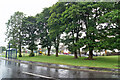
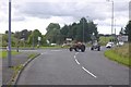
10
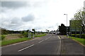
Bus stop and shelter on the A736, Lugton
Road towards Glasgow.
Image: © JThomas
Taken: 23 May 2021
0.05 miles