IMAGES TAKEN NEAR TO
Lugton Road, KILMARNOCK, KA3 4DP
Introduction
This page details the photographs taken nearby to Lugton Road, KA3 4DP by members of the Geograph project.
The Geograph project started in 2005 with the aim of publishing, organising and preserving representative images for every square kilometre of Great Britain, Ireland and the Isle of Man.

There are currently over 7.5m images from over14,400 individuals and you can help contribute to the project by visiting https://www.geograph.org.uk
Image Map (Loading...)


Getting Data...Please wait
Leaflet Map data © OpenStreetMap
Images are licensed for reuse under creativecommons.org/licenses/by-sa/2.0
Notes
- Clicking on the map will re-center to the selected point.
- The higher the marker number, the further away the image location is from the centre of the postcode.
Image Listing (13 Images Found)
Images are licensed for reuse under creativecommons.org/licenses/by-sa/2.0
Image
Details
Distance
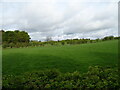
2
Old Gate
On the A735 near Thougritstane. The Glasgow-Dumfries railway line can be seen in the background.
Image: © Thomas Nugent
Taken: 16 May 2006
0.04 miles
4
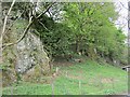
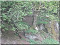
Chapel Craig
An unexpected roadside crag - with goat.
Image: © Richard Webb
Taken: 21 May 2013
0.06 miles
6
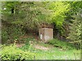
Water Tower
Close to the A735 near Thougritstane.
Image: © Thomas Nugent
Taken: 16 May 2006
0.07 miles
7
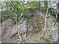
Chapel Craig
Some of the steeper and cleaner rock on a well vegetated crag.
Image: © Richard Webb
Taken: 21 May 2013
0.08 miles
9
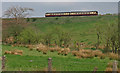
Train Leaving Dunlop
On the Kilmarnock/Barrhead line.
Image: © wfmillar
Taken: 28 Apr 2009
0.16 miles
10
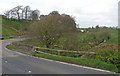
Chapelhouse Bridge, Dunlop
A735 crossing the Black Burn.
Image: © wfmillar
Taken: 28 Apr 2009
0.18 miles