IMAGES TAKEN NEAR TO
Stewarton Road, KILMARNOCK, KA3 4DH
Introduction
This page details the photographs taken nearby to Stewarton Road, KA3 4DH by members of the Geograph project.
The Geograph project started in 2005 with the aim of publishing, organising and preserving representative images for every square kilometre of Great Britain, Ireland and the Isle of Man.

There are currently over 7.5m images from over14,400 individuals and you can help contribute to the project by visiting https://www.geograph.org.uk
Image Map
Images are licensed for reuse under creativecommons.org/licenses/by-sa/2.0
Notes
- Clicking on the map will re-center to the selected point.
- The higher the marker number, the further away the image location is from the centre of the postcode.
Image Listing (20 Images Found)
Images are licensed for reuse under creativecommons.org/licenses/by-sa/2.0
Image
Details
Distance
1
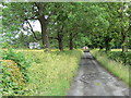
Road to the Hill
Farm road leading to The Hill. The Hill was the home of Barbara Gilmour, who invented Dunlop Cheese after learning the technique for making hard cheese in Ireland.
Image: © James Allan
Taken: 24 Jun 2010
0.03 miles
2

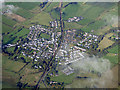
Dunlop from the air
Dunlop is a village on East Ayrshire, at the north side of the former county of Ayrshire, located between Stewarton and Beith. Dunlop railway station and Dunlop Bowling Club can be seen in the centre of the village.
Image: © Thomas Nugent
Taken: 4 Oct 2019
0.10 miles
3
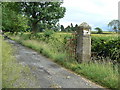
The Hill gatepost
Start of the driveway leading to The Hill farm. The Hill was the home of Barbara Gilmour, who invented Dunlop Cheese after learning the technique for making hard cheese in Ireland.
Image: © James Allan
Taken: 24 Jun 2010
0.16 miles
4
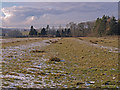
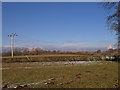
Field, Dunlop
The sun has melted some of the frost and light snow from the ridges in this field. Way in the distance fog fills the Garnock valley below the hills.
Image: © wfmillar
Taken: 17 Feb 2010
0.16 miles
6
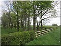
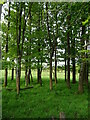
Small wood near The Hill
Looks a bit like a track on the 1:25,000 map.
Image: © Richard Webb
Taken: 21 May 2013
0.19 miles
8
Dunlop from the air
Dunlop is a village on East Ayrshire, at the north side of the former county of Ayrshire, located between Stewarton and Beith. Dunlop railway station and Dunlop Bowling Club can be seen in the centre of the village.
Image: © Thomas Nugent
Taken: 4 Oct 2019
0.20 miles

10
Electricity Poles, Dunlop
Poles carry the power lines across the fields near Dunlop.
Image: © wfmillar
Taken: 17 Feb 2010
0.21 miles