IMAGES TAKEN NEAR TO
Netherhouses Road, KILMARNOCK, KA3 4DF
Introduction
This page details the photographs taken nearby to Netherhouses Road, KA3 4DF by members of the Geograph project.
The Geograph project started in 2005 with the aim of publishing, organising and preserving representative images for every square kilometre of Great Britain, Ireland and the Isle of Man.

There are currently over 7.5m images from over14,400 individuals and you can help contribute to the project by visiting https://www.geograph.org.uk
Image Map
Images are licensed for reuse under creativecommons.org/licenses/by-sa/2.0
Notes
- Clicking on the map will re-center to the selected point.
- The higher the marker number, the further away the image location is from the centre of the postcode.
Image Listing (61 Images Found)
Images are licensed for reuse under creativecommons.org/licenses/by-sa/2.0
Image
Details
Distance
2

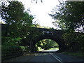
Railway bridge over Stewarton Road (A735)
Carries the Kilmarnock to Glasgow railway.
Image: © JThomas
Taken: 23 May 2021
0.03 miles

4

Stewarton Road, Dunlop
During a heavy rainstorm, I was sheltering under the railway bridge.
Image: © Richard Webb
Taken: 25 Jun 2016
0.05 miles
5

Dunlop from the air
Dunlop is a village in East Ayrshire, at the north side of the former county of Ayrshire, located between Stewarton and Beith. Dunlop railway station and Dunlop Bowling Club can be seen in the centre of the village.
Image: © Thomas Nugent
Taken: 4 Oct 2019
0.07 miles
7

Dunlop from the air
The railway line bisects the village.
Image: © Thomas Nugent
Taken: 16 Mar 2016
0.07 miles

9

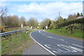
Road access, Glasgow to Kilmarnock railway
There is hard standing here which links road and railway. This would have been used when the line was rebuilt as a double track in 2009. Despite decades of fare increases which have led to once frequent travellers as myself rationing train travel (and many being priced off the network completely) there is a capacity problem and the shrinkages of the 1950s-80s period are being slowly reversed.
Some of the more eyewatering fares are planned to discourage travel and thus reduce overcrowding or the need to hire more rolling stock from one of the many middlemen of post privatisation railways. There is a gravy train.
Image: © Richard Webb
Taken: 21 May 2013
0.10 miles
