IMAGES TAKEN NEAR TO
Creamery Row, KILMARNOCK, KA3 4DA
Introduction
This page details the photographs taken nearby to Creamery Row, KA3 4DA by members of the Geograph project.
The Geograph project started in 2005 with the aim of publishing, organising and preserving representative images for every square kilometre of Great Britain, Ireland and the Isle of Man.

There are currently over 7.5m images from over14,400 individuals and you can help contribute to the project by visiting https://www.geograph.org.uk
Image Map
Images are licensed for reuse under creativecommons.org/licenses/by-sa/2.0
Notes
- Clicking on the map will re-center to the selected point.
- The higher the marker number, the further away the image location is from the centre of the postcode.
Image Listing (67 Images Found)
Images are licensed for reuse under creativecommons.org/licenses/by-sa/2.0
Image
Details
Distance
1
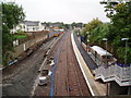
Dunlop Railway Station
The railway station is being rebuilt as part of a project to increase the capacity of the Glasgow to Kilmarnock rail line. Originally built as a dual rail line it was converted to single track from Barrhead to Kilmarnock. Network rail are now installing a long passing loop between Dunlop and Stewarton to allow more trains to run. The single line platform has been demolished and is being rebuilt. The platform on the right is newly built. 10th August 2009 9.40am
Image: © Gordon Dowie
Taken: 10 Aug 2009
0.05 miles
2
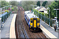
Class 156 DMU arrives at Dunlop Railway Station
Class 156 No. 156507 arrives at Dunlop working a local service from Kilmarnock to Glasgow Central. This particular unit is refurbished to meet new disability regulations.
Dunlop is served by a half hourly service towards to Glasgow and a half hourly service to Kilmarnock with selected services being extended Carlisle and Newcastle via Hexham
Image: © Adam Forsyth
Taken: 28 Apr 2018
0.07 miles
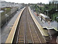
3
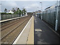
Dunlop railway station, Ayrshire
Opened in 1871 by the Glasgow Barrhead & Kilmarnock Joint Railway, this station closed for a few months in 1966 but reopened in 1967.
View north towards Barrhead and Glasgow.
Image: © Nigel Thompson
Taken: 10 Mar 2014
0.07 miles
5
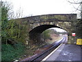
Bridge No. 75
Bridge that carries the minor road over the rail line, photographed looking north from the platform of Dunlop Station.
Image: © Chris Court
Taken: 27 Dec 2005
0.09 miles
6

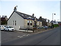
Mansfield Terrace, Dunlop, East Ayrshire
Mansfield Terrace lies just off Stewarton Road.
Image: © Mark S
Taken: 2 Sep 2023
0.09 miles
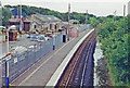
7
Dunlop railway station, Ayrshire
Opened in 1871 by the Glasgow Barrhead & Kilmarnock Joint Railway, this station closed for a few months in 1966 but reopened in 1967.
View south towards Stewarton and Kilmarnock. Between 1975 and 2009, only the platform on the left was in use as the line had been singled. Big changes in the previous 18 years are apparent - see Image
Image: © Nigel Thompson
Taken: 10 Mar 2014
0.09 miles
8
Dunlop station, 1996
View southward, towards Kilmarnock, Dumfries and Carlisle: ex-Caledonian & GSW (Glasgow, Barrhead & Kilmarnock) section of the Glasgow - Kilmarnock - Dumfries - Carlisle main line. The station was closed 11/66-6/67 and the line singled in 1975, but doubled again in 2009.
Image: © Ben Brooksbank
Taken: 8 Jul 1996
0.09 miles
10

Railway bridge over Stewarton Road (A735)
Carries the Kilmarnock to Glasgow railway.
Image: © JThomas
Taken: 23 May 2021
0.09 miles