IMAGES TAKEN NEAR TO
Dunlop, KILMARNOCK, KA3 4BT
Introduction
This page details the photographs taken nearby to KA3 4BT by members of the Geograph project.
The Geograph project started in 2005 with the aim of publishing, organising and preserving representative images for every square kilometre of Great Britain, Ireland and the Isle of Man.

There are currently over 7.5m images from over14,400 individuals and you can help contribute to the project by visiting https://www.geograph.org.uk
Image Map
Images are licensed for reuse under creativecommons.org/licenses/by-sa/2.0
Notes
- Clicking on the map will re-center to the selected point.
- The higher the marker number, the further away the image location is from the centre of the postcode.
Image Listing (4 Images Found)
Images are licensed for reuse under creativecommons.org/licenses/by-sa/2.0
Image
Details
Distance
1
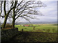
Ravenslie Farm
The red roofed barn of Ravenslie Farm and surrounding fields. In the foreground the boundary wall and trees of Bankhead.
Image: © Chris Court
Taken: 27 Dec 2005
0.02 miles
2

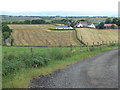
Fields
View to Cauldhame Farm and surrounding Fields. On the horizon in the centre of the picture are the hills of the Island of Arran.
Image: © Chris Court
Taken: 27 Dec 2005
0.18 miles
3
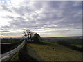
Road to Ravenslie
The farm road leads to Ravenslie farm Image but the buildings in the background are part of Cauldhame Farm Image
Image: © James Allan
Taken: 24 Jun 2010
0.23 miles
4
Shadows
Bankend and horses in the farm field, noticeable are the long shadows cast by the winter sunshine.Photograph taken around midday.
Image: © Chris Court
Taken: 27 Dec 2005
0.24 miles