IMAGES TAKEN NEAR TO
Dunlop, KILMARNOCK, KA3 4BN
Introduction
This page details the photographs taken nearby to KA3 4BN by members of the Geograph project.
The Geograph project started in 2005 with the aim of publishing, organising and preserving representative images for every square kilometre of Great Britain, Ireland and the Isle of Man.

There are currently over 7.5m images from over14,400 individuals and you can help contribute to the project by visiting https://www.geograph.org.uk
Image Map
Images are licensed for reuse under creativecommons.org/licenses/by-sa/2.0
Notes
- Clicking on the map will re-center to the selected point.
- The higher the marker number, the further away the image location is from the centre of the postcode.
Image Listing (9 Images Found)
Images are licensed for reuse under creativecommons.org/licenses/by-sa/2.0
Image
Details
Distance
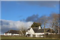
2
Nether Oldhall Farm
Viewed from junction on B706 Dunlop/Burnhouse Road.
Image: © wfmillar
Taken: 22 Feb 2010
0.08 miles
3
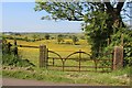
Simple ornament at Oldhall Murray Farm
An unusual gate to buttercup pastures in full flower.
Image: © Alan Reid
Taken: 7 Jun 2018
0.14 miles
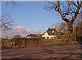
4
Over the Hedge
View over the roadside beech hedge to uncut hedgerow and farm field (with molehills).
Image: © Chris Court
Taken: 27 Dec 2005
0.15 miles
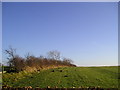
5
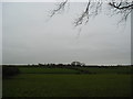
Farmland
View to Oldhall across typical north ayrshire farm fields.
Image: © Chris Court
Taken: 9 Dec 2005
0.17 miles
6
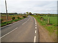
B706 Dunlop to Burnhouse
Silverhill Farm seen in the background.
Image: © Gordon Dowie
Taken: 4 May 2010
0.19 miles
7
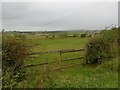
Farmland, Oldhall
Looking towards Burnhouse.
Image: © Richard Webb
Taken: 25 Sep 2015
0.21 miles
8

Silverhill from the air
With Nether Oldhall and Oldhall visible beyond. The B706 road with its 90 degree angle bends can also be seen.
Image: © Thomas Nugent
Taken: 4 Oct 2019
0.22 miles
9
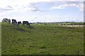
Cattle, Oldhall
Arran in the background.
Image: © Richard Webb
Taken: 9 Sep 2017
0.22 miles