IMAGES TAKEN NEAR TO
Stewarton Road, KILMARNOCK, KA3 4AA
Introduction
This page details the photographs taken nearby to Stewarton Road, KA3 4AA by members of the Geograph project.
The Geograph project started in 2005 with the aim of publishing, organising and preserving representative images for every square kilometre of Great Britain, Ireland and the Isle of Man.

There are currently over 7.5m images from over14,400 individuals and you can help contribute to the project by visiting https://www.geograph.org.uk
Image Map
Images are licensed for reuse under creativecommons.org/licenses/by-sa/2.0
Notes
- Clicking on the map will re-center to the selected point.
- The higher the marker number, the further away the image location is from the centre of the postcode.
Image Listing (76 Images Found)
Images are licensed for reuse under creativecommons.org/licenses/by-sa/2.0
Image
Details
Distance
1
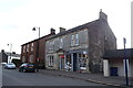
Newsagents on Stewarton Road (A735), Dunlop
Image: © JThomas
Taken: 23 May 2021
0.01 miles
3
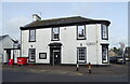
The Merito pub in Dunlop
Owned by the community.
Image: © JThomas
Taken: 23 May 2021
0.02 miles
5
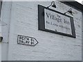
Road sign, Village Inn
A sign on the pub wall in Dunlop.
Image: © Richard Webb
Taken: 21 May 2013
0.02 miles
6
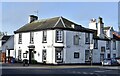
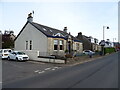
Merito Pub & Restaurant, Dunlop, East Ayrshire
Community owned pub & restaurant.
Category C-listed, built sometime around the early-mid 19th century.
Image: © Mark S
Taken: 2 Sep 2023
0.03 miles
7
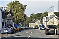
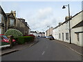
Main Street, Dunlop, East Ayrshire
The view along Main Street.
Image: © Mark S
Taken: 2 Sep 2023
0.03 miles
8
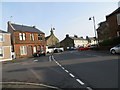
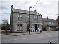
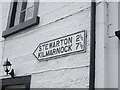
The junction of Main Street (B706) with Stewarton Road (A735) in Dunlop
Looking north-eastward.
Image: © Peter Wood
Taken: 14 Sep 2016
0.03 miles