IMAGES TAKEN NEAR TO
Stewarton, KILMARNOCK, KA3 3ER
Introduction
This page details the photographs taken nearby to KA3 3ER by members of the Geograph project.
The Geograph project started in 2005 with the aim of publishing, organising and preserving representative images for every square kilometre of Great Britain, Ireland and the Isle of Man.

There are currently over 7.5m images from over14,400 individuals and you can help contribute to the project by visiting https://www.geograph.org.uk
Image Map
Images are licensed for reuse under creativecommons.org/licenses/by-sa/2.0
Notes
- Clicking on the map will re-center to the selected point.
- The higher the marker number, the further away the image location is from the centre of the postcode.
Image Listing (5 Images Found)
Images are licensed for reuse under creativecommons.org/licenses/by-sa/2.0
Image
Details
Distance
2
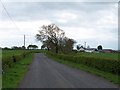
Righead Plantation
The plantation is now just a thin strip wood.
Image: © Richard Webb
Taken: 21 May 2013
0.14 miles
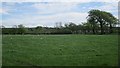
3
Railway bridge
Over the Glasgow-Dumfries line near Stewarton. Looks like farm animals get their own bridge!
Image: © Thomas Nugent
Taken: 16 May 2006
0.15 miles
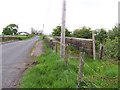
4
Railway bridge, Gameshill
There is a path for the cows too. Crosses the Kilmarnock to Glasgow railway.
Image: © Richard Webb
Taken: 21 May 2013
0.20 miles
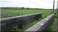
5
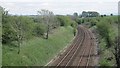
Glasgow to Kilmarnock railway
Now back to double track working.
Image: © Richard Webb
Taken: 21 May 2013
0.24 miles