IMAGES TAKEN NEAR TO
Stewarton, KILMARNOCK, KA3 3EP
Introduction
This page details the photographs taken nearby to KA3 3EP by members of the Geograph project.
The Geograph project started in 2005 with the aim of publishing, organising and preserving representative images for every square kilometre of Great Britain, Ireland and the Isle of Man.

There are currently over 7.5m images from over14,400 individuals and you can help contribute to the project by visiting https://www.geograph.org.uk
Image Map
Images are licensed for reuse under creativecommons.org/licenses/by-sa/2.0
Notes
- Clicking on the map will re-center to the selected point.
- The higher the marker number, the further away the image location is from the centre of the postcode.
Image Listing (6 Images Found)
Images are licensed for reuse under creativecommons.org/licenses/by-sa/2.0
Image
Details
Distance
1
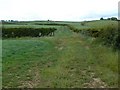
Hedges and fields
North of the B778 road near South Kilbride Farm.
Image: © James Allan
Taken: 24 Jun 2010
0.11 miles
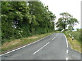
2
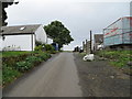
Lane passing through North Kilbride
Looking south-westward.
Image: © Peter Wood
Taken: 14 Sep 2016
0.11 miles
3
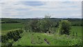
Green lane, North Kilbride
Grass covered road to Irvinehill.
Image: © Richard Webb
Taken: 21 May 2013
0.12 miles
4
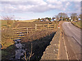
Burn and Bridge, B778 Road
No names on the map for this burn or bridge. Burn joins the Glazert Burn approximately 1Km down stream. North Kilbride Farm on the road side.
Image: © wfmillar
Taken: 22 Feb 2010
0.14 miles
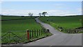
6
B778 road near South Kilbride Farm
Tree lined minor road.
Image: © James Allan
Taken: 24 Jun 2010
0.18 miles