IMAGES TAKEN NEAR TO
Stewarton, KILMARNOCK, KA3 3EN
Introduction
This page details the photographs taken nearby to KA3 3EN by members of the Geograph project.
The Geograph project started in 2005 with the aim of publishing, organising and preserving representative images for every square kilometre of Great Britain, Ireland and the Isle of Man.

There are currently over 7.5m images from over14,400 individuals and you can help contribute to the project by visiting https://www.geograph.org.uk
Image Map
Images are licensed for reuse under creativecommons.org/licenses/by-sa/2.0
Notes
- Clicking on the map will re-center to the selected point.
- The higher the marker number, the further away the image location is from the centre of the postcode.
Image Listing (8 Images Found)
Images are licensed for reuse under creativecommons.org/licenses/by-sa/2.0
Image
Details
Distance
2
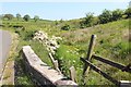
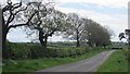
East Bloakhillhead
A field and small wood near East Bloakhillhead.
Image: © Richard Webb
Taken: 25 Sep 2015
0.07 miles
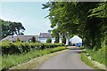
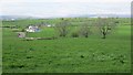
4
Farmland near Bloakholmes
The picture looks west across grasslands towards the farm at Bloakholmes.
Image: © Alec MacKinnon
Taken: 21 Oct 2021
0.18 miles
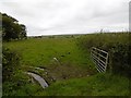
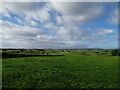
5
Green field
Bloakhillhead: after a slow start, the grass is growing now.
Image: © Richard Webb
Taken: 21 May 2013
0.18 miles
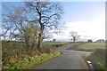
6
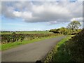
Minor road south of the B778
Bordered by hawthorn hedgerows this single-track road is seen here looking north towards the crossroads where it meets the B778.
Image: © Alec MacKinnon
Taken: 21 Oct 2021
0.19 miles