IMAGES TAKEN NEAR TO
Stewarton, KILMARNOCK, KA3 3EL
Introduction
This page details the photographs taken nearby to KA3 3EL by members of the Geograph project.
The Geograph project started in 2005 with the aim of publishing, organising and preserving representative images for every square kilometre of Great Britain, Ireland and the Isle of Man.

There are currently over 7.5m images from over14,400 individuals and you can help contribute to the project by visiting https://www.geograph.org.uk
Image Map
Images are licensed for reuse under creativecommons.org/licenses/by-sa/2.0
Notes
- Clicking on the map will re-center to the selected point.
- The higher the marker number, the further away the image location is from the centre of the postcode.
Image Listing (6 Images Found)
Images are licensed for reuse under creativecommons.org/licenses/by-sa/2.0
Image
Details
Distance
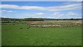
2
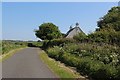
Kennox Moss
Damp pasture with a surviving area of bog. Oh and a bath in a field.
Image: © Richard Webb
Taken: 25 Sep 2015
0.04 miles
3
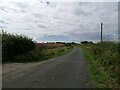
Minor road from Crossgates
We look south-west along this single track road which runs from the farm at Crossgates across the country towards Dunlop.
Image: © Alec MacKinnon
Taken: 5 Jul 2023
0.05 miles
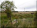
4
Edge of the field
In quiet Ayrshire farmland near Crossgates, the edge of this field is marked by both fence and hedgerow. The gate in the foreground opens - or possibly opened given its current state - from the minor road that heads north towards Dunlop.
Image: © Alec MacKinnon
Taken: 5 Jul 2023
0.07 miles
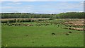
5
Kennox Moss
The edge of a large wetland and bog area.
Image: © Richard Webb
Taken: 21 May 2013
0.10 miles
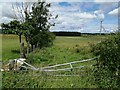
6
Kennox Moss
Some of the mossland is wooded.
Image: © Richard Webb
Taken: 21 May 2013
0.24 miles