IMAGES TAKEN NEAR TO
Stewarton, KILMARNOCK, KA3 3EH
Introduction
This page details the photographs taken nearby to KA3 3EH by members of the Geograph project.
The Geograph project started in 2005 with the aim of publishing, organising and preserving representative images for every square kilometre of Great Britain, Ireland and the Isle of Man.

There are currently over 7.5m images from over14,400 individuals and you can help contribute to the project by visiting https://www.geograph.org.uk
Image Map
Images are licensed for reuse under creativecommons.org/licenses/by-sa/2.0
Notes
- Clicking on the map will re-center to the selected point.
- The higher the marker number, the further away the image location is from the centre of the postcode.
Image Listing (8 Images Found)
Images are licensed for reuse under creativecommons.org/licenses/by-sa/2.0
Image
Details
Distance
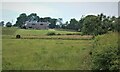
3
Winding Road
The building appears to have been renovated quite recently; I believe it is called Watermeetings.
Image: © Thomas Nugent
Taken: 25 May 2006
0.12 miles
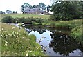
4
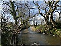
Confluence
The Annick Water at the confluence with the Glazert Burn.
Image: © Richard Webb
Taken: 21 May 2013
0.14 miles
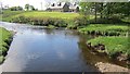
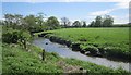
5
Looking along the Glazert Burn
The picture looks south along the burn near its meeting with the Annick Water. Through the trees the bridge that crosses the burn just before a 'T' junction can be spotted.
Image: © Alec MacKinnon
Taken: 8 Apr 2022
0.17 miles
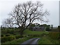
7
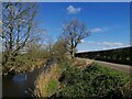
Glazert Burn and minor road
The picture shows the Glazert Burn and accompanying minor road just north of its meeting with the Annick Water.
Image: © Alec MacKinnon
Taken: 8 Apr 2022
0.22 miles
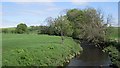
8
Glazert Burn
Near the confluence with the Annick Water.
Image: © Richard Webb
Taken: 21 May 2013
0.25 miles